Route Editor

| Guide | ♦ | 209 Triplogs | 9 Topics |
details | drive | no permit | forecast | route |
stats |
photos | triplogs | topics | location |
| 1.6k | 209 | 9 |
  Overview OverviewRipping into the edge of the Mogollon Rim, Wet Beaver Creek is an oasis. The trail is wide and easy to follow, with many options along the way. If you like Sedona and love West Fork of Oak Creek, try this creek. You can follow the Bell Tail for an average tour or skirt the creek for memories of a lifetime. Families Hike 0.3 to 0.7 mi, then turn right down to the creek. If you have small children, skip the hike and go to the "Beaver Creek Picnic and Day Use Area," where FR618 crosses the creek.
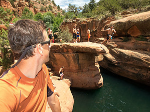
From the trailhead, it's a leisure stroll. The trail is an old jeep trail. Follow this trail to the real trailhead 2.3 miles ahead at the Wet Beaver Wilderness boundary. You can bike the two-mile distance to save some time. The first section isn't a bad hike, in my opinion. As far as mountain biking goes, it's not exciting. I do recommend shooting down to the creek a couple of times in the beginning. Some come for this quick and beautiful section of deep red Sedona sandstone that levels across the creek bed in parts. As a filming buddy said, this is a great area to shoot a walking on water sequence. Trees canopy the creek. It's a refreshing play area during the hottest days of summer. Families with kids usually opt for this quick venture. Along the north side of the creek is an old human-made canal used by the natives to irrigate the land. Continue to the Bell Trailhead. It's worthy to note you can follow the creek. The going is slow due to overgrowth. I did the creek scramble years ago, and it was a blast. I probably won't do it again. It took the entire day. Okay, back on the trail to the Bell Trailhead. About a mile into the trail, notice the correction school across the creek and higher up on the south bank. I have hiked this trail numerous times and seen little activity over there, not that it matters. Prickly pear may not be the most exciting cacti plant as it grows nearly everywhere. Yet, along this stretch, large thick patches appear to be healthier than most. Including lots of Engelmann's, as shown in some of my pictures. However, I'm not sure about that due to the beautiful budding purple fruit. Not the rarer Purple Prickly Pair, though some are along the trail. Keep an eye out for petroglyphs. A visit to nearby V-Bar-V Heritage Trail and a chat with the attendant may reveal some clues! Along the way, you will pass two other trails taking off north. The first at 1.5 miles is the White Mesa Trail #86. Checking out the trail log, I was amused at an entry that read "this trail bites." A bit further on at about 1.75 miles, the Apache Maid Trail #15 takes off. #15 heads out for a long venture loop, and I haven't heard anything good about this one either. Crossing another wash or two, you'll come in with the Bell & Weir trailheads. The Weir continues to the right and curves on down to the creek. An old water gauging station is not much to look at, but swimming is suitable for kids. The Bell Trail takes off to the left and begins ascending right away. This is the trail you are looking for to reach the real rewards. Heading on up to the ledge that skirts the canyon wall, you will notice a quick change of scenery. Up until now, you were hiking through tall grass meadows. Now you will feel like you're back in Sedona. This is just an impressive section of the trail. You will be looking over at the creek below. The path hugs the contours going in and out, up and down. This is hiking Arizona style! When the trail begins to head on back down to the creek, you are approaching Bell Crossing. Named after the old rancher Charles Bell for whom you have to thank for making this trail. Just before the trail drops down into the creek, a spur trail takes off to your left. This is the path to the "Tongue of the Beaver." Within a very short distance, you will see the beaver's tongue. It looks like a big diving board. Umm... don't jump off, the water is usually only a few feet deep here. This is a great photo area so bring the camera. Sometimes this Arizona gem is packed with sunbathers. Then there are times you get the whole area to yourself. Usually early in the week on an overcast day. A short venture further into this canyon is fun too. For an extended hike cross Bell Crossing. The trail continues up to the Rim. More natural jewels are encountered within the first mile and half. All in all, this is one of the better hikes in Arizona. Many options are presented along the way. There's even a tight triple-steep canyon on the south bank just packed with trees. If you're into exploring, this hike ranks with the best. Enjoy! Montezumawell adds What Joe called 'Tongue of the Beaver' is known to the 'locals' as 'The Crack.' It's a mega party scene there at certain times. Other times, no one in sight. Ditto with the Weir. We've camped at the Weir a few times. The trick is to walk in at dusk to make sure no one's there and then leave right after sunup. It's a hectic trail, a 'must-do' for practically every Boy Scouting group in the Southwest. Since the TH is only a 13-minute drive from our home, we hike this trail often, even if only for a 15-minute stroll up to the petroglyph rock and the nearby red ledges in the creek. Ah, to hear the water gurgle over those ledges. Bear in mind that, if this trail and creek were in Sedona, it would be one of the 'major draws' over there. Probably would have been homesteaded and then sold to an Enchantment-style developer. Somehow, this trail stayed public. Thank The Trail Gods! Anyway, Joe's right, don't bother with White Mesa or Apache Maid unless you are bored out of your mind. Hang out at The Crack and watch the 'local color' do their thing or splish and splash in the pool of your own choice. Do realize this is prime snake habitat due to the excellent rodent population. It's not a big deal, but you should always keep your eyes open for rattlesnakes. They are very common. Less so down by the water, but they DO sometimes hang out there, too. Just be cautious. A side note That Bell fellow was an Eastern industrialist who came to visit one of the resorts which once lined Beaver Creek. He fell in love with the cowboy lifestyle and was probably much like Billy Crystal in 'City Slickers.' He bought a ranch and literally threw money at every project you can imagine. The Bell Trail was one of his more grandiose and expensive ideas. None of the 'locals' of that era could possibly afford to spend that kind of money blasting a cattle driveway out of Beaver Creek's sheer cliffs. They drove their herds up existing slopes scattered along the Mogollon Rim. Not ol' Mr. Bell! So, whenever you hike the Bell Trail, tip your hat too early tourism. You are walking an indirect relic of the once-thriving resort business, which made Beaver Creek famous nationwide in the pre-depression 1920s.
Coconino FS Details This trail is the only developed route into Wet Beaver Creek Canyon and the Wilderness Area it shelters. It is a very popular trail with hikers and anglers who come to enjoy the solitude and other rewards offered by a clear cool stream flowing through a scenic desert canyon. For the most part, the trail follows a route along a bench well above the streambed. Several side trails, however, lead down to the waterside and indicate the location of good swimming holes or popular fishing spots. If you take advantage of these well-used detours, you'll find some places along the stream where deepwater holes alternate with bubbling riffles to invite you to take a dip or wet your line. At one point the trail leaves the canyon bottom to wind high along an escarpment of red sandstone and offers scenic views of the riparian area, the canyon, and the surrounding mountains and valleys. Most people who come to this trail hike only the first 3.3 miles to Bell Crossing, taking advantage of any of several access paths that branch off the main trail and lead down to the stream. After crossing the Wet Beaver Creek, the Bell Trail climbs the canyon's south wall to a high, grassy plateau where it winds through pinyon-juniper stands and open grasslands offering views that stretch to the Sedona Red Rocks Country and the San Francisco Peaks. Eleven miles from the Beaver Creek trailhead Bell Trail ends at Forest Road 24.
Check out the Official Route and Triplogs. Leave No Trace and +Add a Triplog after your hike to support this local community. | |||||||||||||||||||||||||||||||||||||||||||||||||||||||||||||||||||||||||||||||||||||||||||||||||||||||||||||||||||||||||||||||||||||||||||||||||||||||||||||||||||||||||||||||||||||||||||||||||||||||||||