 Route Editor

| Guide | ♦ | 7 Triplogs | 0 Topics |
details | drive | no permit | forecast | 🔥 route |
stats |
photos | triplogs | topics | location |
| 28 | 7 | 0 |
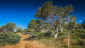
Just Peachy Keen by pseudalpine   Overview OverviewThis short multi-use road hike forms a semi-loop shaped like a C and is located west of the north section of the equivalent Peach Orchard Trail - PATS. Hike From the Peach Orchard TH gate parking, one must hike a quarter mile south on FR 441 to reach the FR 510 junction. The west (right) fork is the official start of this route. At the 0.57-mile point, the route crosses a saddle that overlooks a solar farm located below in American Gulch to the north. From here, the trail turns left, tracking generally southwest another 0.57 miles to its highpoint at ~5056'. There's a signpost at this point that is labeled most difficult, where another left turn descends steeply east on a much narrower, rockier, and eroded path. After another half-mile, this rough road junctions into FR 441 again near Orchard Tank.
An easier, yet analogous route to the main Peach Orchard Trail that transects similar Interior Chaparral landscapes with the main views of the Mazatzal Mountains to the south. Gate Policy: If a gate is closed upon arrival, leave it closed after you go through. If it is open, leave it open. Leaving a closed gate open may put cattle in danger. Closing an open gate may cut them off from water. Please be respectful, leave gates as found. The exception is signage on the gate directing you otherwise.
Check out the Official Route and Triplogs. Leave No Trace and +Add a Triplog after your hike to support this local community. One-Way Notice This hike is listed as One-Way. When hiking several trails on a single "hike", log it with a generic name that describes the hike. Then link the trails traveled, check out the example. | |||||||||||||||||||||||||||||||||||||||||||||||||||||||||||||||||||||||||||||||||||||||||||||||||


