 Route Editor

| Guide | ♦ | 16 Triplogs | 1 Topic |
details | drive | permit | forecast | route |
stats |
photos | triplogs | topic | location |
| 52 | 16 | 1 |
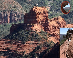
All aboard! by joebartels   Approach ApproachFollow Wilson Canyon Trail about 0.55 miles. History Named after a trapper that chased a bear into this canyon. The bear turned on Wilson. Without a charge in his muzzle-loading rifle, he climbed a juniper. The bear dragged him out and killed him. Lesson learned. Rumors crested around 1914 as reports surfaced of old man Wilson haunting the canyon. Scribbled legend has it that spooked horses pranced in terror as the apparition circled noisily. Locals Tex Ownby and Wright Clark fiddled a tale the noise was the rifle dragging around, slamming against the rocks.
Take a left on Jim Thompson Trail and follow for two-tenths of a mile. Jim was just a rancher, and this segment is safe! Icon Steamboat Rock is a half-mile off-trail up the slickrock. Cairns may help if you stumble upon the correct set. Check out the final route up the rock. Switch the map to satellite for a good overview. For the intrepid researcher that reads descriptions, here is the full route. The out-n-back is a 2.6mi / 810aeg hike. Too scary for some. Similar to playing around on Papago Buttes in Phoenix, one must be careful and know their limits. It is a class 3 scramble if you find the correct route. Which means you could die from a fall. If it seems too risky, don't do it. Remember, it's usually more difficult getting down than up. I haven't done the top. I'd imagine it's class four or above. Nevertheless, the views from near the top are well worth the moderate effort for this hike. Amazingly, it hasn't become more popular. Many of the Sedona area hikes are short tourist jaunts. Bruce and I incorporated Steamboat into an 18 mile loop in 2012. Lack of waterfalls and dancing girls will keep this one under the radar.
Check out the Official Route and Triplogs. Leave No Trace and +Add a Triplog after your hike to support this local community. One-Way Notice This hike is listed as One-Way. When hiking several trails on a single "hike", log it with a generic name that describes the hike. Then link the trails traveled, check out the example. | |||||||||||||||||||||||||||||||||||||||||||||||||||||||||||||||||||||||||||||||||||||||||


