Mesquite Canyon - Waddell - Ford Canyon Loop, AZ | HikeArizona
username
X
password
register
for free!
help
  This is likely a great time to hike this trail!  Check out "Preferred" months below, keep in mind this is an estimate.
  

Mesquite Canyon - Waddell - Ford Canyon Loop, AZ

Guide 53 Triplogs  0 Topics
  3.7 of 5 
Fav
Wish
3
details
drive
permit
forecast
route  
stats
photos
triplogs
topics
location
566 53 0
Statistics
tap icons for details
Difficulty 3 of 5
Route Finding 2 of 5
Distance Loop 10.6 miles
Trailhead Elevation 1,542 feet
Elevation Gain 1,368 feet
Accumulated Gain 1,921 feet
Avg Time Round Trip 5 hours
Kokopelli Seeds 20.21
 Interest Seasonal Waterfall & Seasonal Creek
feature photo
Photos Viewed All MineFollowing
Inaugural Calculation on Button Tap!
15  2023-02-11
Mesquite-Waddell-Ford Cyn Loop & Goldwater
John10s
108  2022-11-28 AZClaimjumper
29  2022-04-02 astrobrewer
11  2022-04-01 LindaAnn
35  2022-04-01 tibber
5  2021-02-15
Barry Goldwater Peak via Mesquite Canyon
GrangerGuy
12  2020-12-05
Barry Goldwater Peak
LindaAnn
11  2020-12-05
Barry Goldwater Peak
AugustWest
Page 1,  2,  3,  4,  5
Author
author avatar Guides 16,880
Routes 17,288
Photos 24
Trips 1 map ( 6 miles )
Age 26 Male Gender
Location HAZ, TrailDEX
Associated Areas
list map done
Phoenix Region
Historical Weather
Trailhead Forecast
Radar Map
Expand Map
Preferred Mar, Nov, Feb, Dec
Sun  6:50am - 6:32pm
Official Route
 
7 Alternative
 
 Water


  Likely In-Season!
Guide Needed
Publish Full Detail Guide


Use +Add above to share photos and triplogs


Check out the Official Route and Triplogs.


Leave No Trace and +Add a Triplog after your hike to support this local community.

2012-05-23
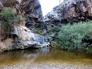
    WARNING! Hiking and outdoor related sports can be dangerous. Be responsible and prepare for the trip. Study the area you are entering and plan accordingly. Dress for the current and unexpected weather changes. Take plenty of water. Never go alone. Make an itinerary with your plan(s), route(s), destination(s) and expected return time. Give your itinerary to trusted family and/or friends.

     Permit $$
    Maricopa Regional Parks - 2021 [ fees ]

    $7 per vehicle,$85 annual or trade your first born for the life pass

    $2 walk, bike or horse ride into park

    2021 [ hours ] - varies by park & season


     Directions
    or
    or
     Road
    Paved - Car Okay

    To Area 7 Trailhead
    From the 303 & Olive go west on Olive 4.5 miles to the park entrance. Olive turns into White Tank Mountain Rd. Continue 2.1 miles, turn right and it's 250 feet to to the Mesquite/Ford Trailhead

    You get a map when you pay your entrance fee so that should help you figure it out if you have any concerns.

    From PHX (I-10 & AZ-51) 39.2 mi, 58 mins
    From TUC (Jct 1-10 & Grant) 146 mi, 2 hours 38 mins
    From FLG (Jct I-17 & I-40) 153 mi, 2 hours 40 mins
    page created by joebartels on May 23 2012 4:50 pm
    helpcorrectionissue

    end of page marker