username
X
password
register
for free!
help
 This is likely a great time to hike this trail!  Check out "Preferred" months below, keep in mind this is an estimate.
  

Arcadia Nature Trail, AZ

Guide 13 Triplogs  0 Topics
  2.3 of 5  
Fav
Wish
0
details
drive
permit
forecast
map
stats
photos
triplogs
topics
location
35 13 0
Statistics
tap row or icons for details
Difficulty 0.5 of 5
Distance One Way 0.5 miles
Trailhead Elevation 6,690 feet
Elevation Gain 100 feet
Kokopelli Seeds 0.83
unreported if dogs are allowed
editedit > ops > dogs to adjust
feature photo
Photos Viewed All MineFollowing
6  2018-04-18 cactuscat
26  2016-04-26
Riggs Flat Campground
Stoic
3  2012-05-24 outdoor_lover
Author
author avatar Guides 16,843
Routes 17,472
Photos 24
Trips 1 map ( 6 miles )
Age 28 Male Gender
Location HAZ, TrailDEX
Associated Areas
list map done
Tucson Region
Historical Weather
Trailhead Forecast
Expand Map
Preferred Oct, Apr, May, Sep
Sun  5:56am - 6:40pm
0 Route
 
1 Alternative


remove free decal offer

 Likely In-Season!
Guide Needed
Publish Full Detail Guide


Use +Add above to share photos and triplogs
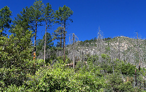
Overview: This short & easy nature trail takes you east along the mountain side through a nice pine-oak forest gently climbing up to a scenic overlook of the Noon Creek ridge line to the north & down to Wet Canyon below.


    Check out the Triplogs.
    Leave No Trace and +Add a Triplog after your hike to support this local community.

    One-Way Notice
    This hike is listed as One-Way.

    When hiking several trails on a single "hike", log it with a generic name that describes the hike. Then link the trails traveled, check out the example.
    WARNING! Hiking and outdoor related sports can be dangerous. Be responsible and prepare for the trip. Study the area you are entering and plan accordingly. Dress for the current and unexpected weather changes. Take plenty of water. Never go alone. Make an itinerary with your plan(s), route(s), destination(s) and expected return time. Give your itinerary to trusted family and/or friends.

     Permit $$
    None

    Coronado Forest
    MVUMs are rarely necessary to review unless mentioned in the description or directions
    Coronado Motor Vehicle Use Maps (MVUMs)


     Directions
    or
     Road
    FR / Dirt Road / Gravel - Car Okay

    To hike
    From Safford, head south on U.S. highway 191. The trail is located at the Upper Arcadia Campground and Picnic Area off Swift Trail (AZ 366) 11.5 miles from the AZ 366/US 191 intersection. The nature trail starts from behind the big water tank just above and parallel to the stone wall above the group picnic area.
    page created by SkyIslander18 on May 26 2012 10:21 am
     90+° 8am - 6pm kills
    helpcorrectionissue

    end of page marker