 Route Editor

| Guide | ♦ | 96 Triplogs | 2 Topics |
details | drive | permit | forecast | 🔥 route |
stats |
photos | triplogs | topics | location |
| 909 | 96 | 2 |
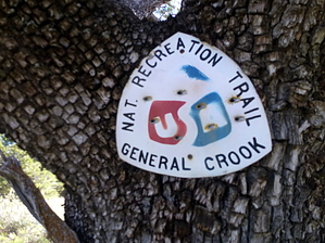
From Fort to Pines - V0 - V55.5 by The_Eagle  Overview OverviewThis historic trail currently starts in the high desert of 5000’, approximately 20 miles east of its original start at Ft Whipple in Prescott. It passes through the site of Ft Verde before climbing to the Mogollon Rim’s tall pines at almost 8000’. Its current eastern terminus at the Cottonwood Wash TH, is some 145 miles and 10,750’ in Accumulated Elevation Gain, from its start. The trail spans Prescott, Coconino, and Apache-Sitgreaves. National Forests (Trails #64, #130, #140). The original western start at Ft Whipple (now the Prescott VA Hospital area) to its current start around P20, is not established or marked, but the general path is known. The original eastern portion of this trail from V113 to Ft Apache is a little less known and may have used numerous routes.
The Trail was developed as a supply route to Ft. Apache from Fort Whipple in Prescott. The scouting for the trail was started in 1871 with General Crook and a small party leaving Ft Apache heading north, and then traversing the rim to the west, arriving at Ft Whipple on September 6th. Actual trail construction began in the spring of 1872 from Ft Whipple (Prescott) and the Show Low area, both heading towards Ft Verde. By 1873 the first pack train with supplies made the trip from Ft Whipple to Fort Apache. One year later the first wagon trains made the journey. For 22 years the trail was used by Crook’s men to patrol the northern border of the Apache Reservation. Infrequent Civilian use continued for another 24 years until the Rim Road was built in 1929. This trail was designated as the state’s first Arizona State Historic Trail The trail was marked for distances from Ft Verde. Markers to the west of Fort Verde were indicated with a “P” (for the Prescott side) and the Miles from Ft Verde (ie P7 was 7 miles west of Ft Verde). On the east side, markers were indicated with a “V”. V20 would indicate 20 miles from Ft Verde on the way to Ft Apache. Distances back then were derived from counting the number of rotations of a wagon wheel. Only a few of the original blazes remain. The best example is possibly 13-mile rock, (V13) which can be seen at the pullout on route 260 on the way up the rim. Reestablishment of the Trail The Grand Canyon Council Boy Scouts of America, Troop 26, re-traced and re-marked the current trail. They did this for their Bicentennial Project starting in 1976. In the western/lower elevations they marked the trail with rocks in wire baskets and Mileage markers on 4” x 4” posts. As of this description, many of the posts remain, but none of the mileage signs have survived. Once in the higher elevations where trees are present, the location of the trail is indicated with white or red metal “V’s” attached to trees of posts. Mileage markers are placed on 6” diameter posts approx. 4’ tall. Mileage is etched into the slanted top of this post (ie. V 21) Warning The Boy Scouts did a great job back in 1976 hiking and marking this trail as part of their Bi-Centennial project. Without this effort, it would not have been possible for us to hike it. The trail is a bit hard to follow in spots, Some spots are marked better than others. If you haven’t seen a “V” chevron on a tree for a while, turn around and check the backside of the trees and also check on some of the fallen trees. A GPS with a loaded track is a really important tool on this trail. Additional Reference Material “A Guide to the General Crook Trail” Published by the Museum of Northern Arizona Press and the Boy Scouts of America Copyright 1978 Hardcopy purchased online “General Crook National Historic Study Trail – Study Report” USDA Forest Service SW Region Sept 1986 Found on the internet Water Availability See Spring Reports Additional Trail Segments The remainder of the current General Crook Trail is made up of the following Trail descriptions. Please see one of the following Descriptions and GPS Tracks for the remainder of the trails. P21 – 0 (Ft Verde) General Crook Trail #64 - Prescott NF, AZ V55.5 – V113 General Crook Trail #140 - Apache SitgreavesNF, AZ Hike The first 6.5 miles will be the least favorite portion for most. Leaving the Fort, you are in the city for a ½ mile then walking next to SR 260 for 6 additional miles before you finally turn into Clear Creek Camp Grounds. Top off on your water here and enjoy the stream because your climb starts momentarily and continues to V16. The next reliable water is up on the Rim at General Springs. A GPS is handy starting at this point, even though some remnants of the Boy Scouts' work still survive. You may see 4 x 4 wooden posts (minus any signage), placed at 1-mile intervals. Cairns, caged cairns, and the "V" chevrons become more prevalent once the trees become more prevalent. The old roadbed/path is visible off and on. The trail roughly follows the same path as SR260 during its 3,000’ climb. You’ll begin to notice a prominent peak during your climb out of Clear Creek. This is 13 Mile Rock Butte. This marks the 13-mile point out of Camp Verde. The original etching for the thirteen-mile mark can be found on the Southside of the Butte and SR260. It’s in the pullout, but is not on the large rock with the plaque, but on a smaller one, a few feet to the northeast. Wire Basket cairns give way to round wooden 4’ tall posts with “V**” Mileage Markers. Beige and or Red “V” start appearing as you get into more and taller trees. On FS144 at the place where marker V28 should be, we had trouble finding the path here. My reference material said to turn right at the Cow Guard. We did and were able to find our way, but we went a bit before finding any sort of trail markers. Directly after the trail crosses SR87, you see the second of the many Trail Marker posts at V31 right next to SR87. You are now in the tall pines and on your way to Baker Lake. (The small mud hole right after you turn off of SR87 onto the Rim Road FR300). After a rough winter, the fallen trees may make passage a little more time-consuming for the next 30 miles or so. The grave of Andres Moreno can be found right off of FR300 before getting to the lookout. It’s not right on the actual Trail. See the waypoint in the GPS Track for location. On July 16, 1887, while traveling in a wagon trail to Prescott, he was shot in the back and killed by an ex-convict he had arrested several years before. He was buried on the trail. This is the first of 6 graves you’ll pass along the General Crook Trail. 3 of them are actually about a ½ mile off the trail. Baker Butte and the Lookout tower are the next landmarks you’ll pass around V34.5. Remnants of the old Military Telegraph lines can be seen in the way of white insulators high in some of the trees. These lines connected Forts Whipple, Verde, and Apache. My first example of this was as we crossed FR300, ¼ mile before getting to the Baker Butte Lookout Tower. Starting at about V40, you begin to get some spectacular views off the rim. Take some time and leave the trail to take a break or lunch and swallow in the views. General Springs at V43-1/4 is the area where many camped and rested on their journey along the trail. The spring was once much more reliable than it currently is. In 1941 a large fire camp was moved into the area. The heavy use caused it to dry up. The original Spring Box can still be seen. At V55-1/2, just before entering the Apache Sitgreaves National Forest, you pass the grave of G.D. Bantz- Died Oct 6, 1895. He was killed when trying to get off the Rim quickly, attempting to beat an impending snowstorm. He hit his mule with the butt of his shotgun when it discharged into his stomach, killing him. He was buried where he dropped. Check out the Official Route and Triplogs. Leave No Trace and +Add a Triplog after your hike to support this local community. One-Way Notice This hike is listed as One-Way. When hiking several trails on a single "hike", log it with a generic name that describes the hike. Then link the trails traveled, check out the example. | ||||||||||||||||||||||||||||||||||||||||||||||||||||||||||||||||||||||||||||||||||||||||||||||||||||||||||||||||||||||||||||||||||||||||||||||||||||||||||||||||||||||||||||||||||||||||||||||||||||||||||||||||||||||||||||||||||||||||||||||||||||||||||||||||||||||||||||||||||||||||||||||||||


