 Route Editor

| Guide | ♦ | 7 Triplogs | 0 Topics |
details | drive | permit | forecast | 🔥 route |
stats |
photos | triplogs | topics | location |
| 151 | 7 | 0 |
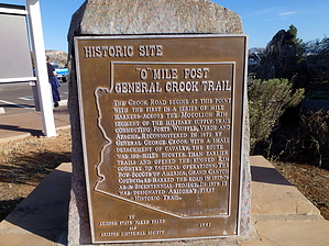
Fort Verde or Bust - P20 to V0 by The_Eagle   Overview OverviewThis historic trail currently starts in the high desert of 5000', approximately 20 miles east of its original start at Ft Whipple in Prescott. It passes through the site of Ft Verde before climbing to the Mogollon Rim's tall pines at almost 8000'. Its current eastern terminus at the Cottonwood Wash TH, is some 145 miles and 10,750' in Accumulated Elevation Gain, from its start. The trail spans Prescott, Coconino, and Apache-Sitgreaves. National Forests (Trails #64, #130, #140). The original western start at Ft Whipple (now the Prescott VA Hospital area) to its current start around P20, is not established or marked, but the general path is known. The original eastern portion of this trail from V113 to Ft Apache is a little less known and may have used numerous routes.
The trail was developed as a supply route to Ft. Apache from Fort Whipple in Prescott. The scouting for the trail was started in 1871 with General Crook and a small party leaving Ft Apache heading north, and then traversing the rim to the west, arriving at Ft Whipple on September 6th. Actual trail construction began in the spring of 1872 from Ft Whipple (Prescott) and the Show Low area, both heading towards Ft Verde. By 1873 the first pack train with supplies made the trip from Ft Whipple to Fort Apache. One year later, the first wagon trains made the journey. For 22 years, the trail was used by Crook's men to patrol the northern border of the Apache Reservation. Infrequent Civilian use continued for another 24 years until the Rim Road was built in 1929. This trail was designated as the state's first Arizona State Historic Trail. The trail was marked for distances from Ft Verde. Markers to the west of Fort Verde were indicated with a "P" (for the Prescott side) and the Miles from Ft Verde (ie: P7 was 7 miles west of Ft Verde). On the east side, markers were indicated with a "V". V20 would mean 20 miles from Ft Verde on the way to Ft Apache. Distances back then were derived from counting the number of rotations of a wagon wheel. Only a few of the original blazes remain. The best example is possibly 13-mile rock, (V13), which can be seen at the pullout on route 260 on the way up the rim. Reestablishment of the Trail The Grand Canyon Council Boy Scouts of America, Troop 26, re-traced and re-marked the current trail. They did this for their Bicentennial Project starting in 1976. In the western/lower elevations, they marked the path with rocks in wire baskets and Mileage markers on 4" x 4" posts. As of this description, many of the posts remain, but none of the mileage signs have survived. Once in the higher elevations where trees are present, the location of the trail is indicated with white or red metal "V's" attached to trees of posts. Mileage markers are placed on 6" diameter posts approx. 4' tall. Mileage is etched into the slanted top of this post (ie: V 21) Warning The Boy Scouts did a great job back in 1976, hiking and marking this trail as part of their Bi-Centennial project. Without this effort, it would not have been possible for us to hike it. The trail is a bit hard to follow in spots. Some spots are marked better than others. If you haven't seen a "V" chevron on a tree for a while, turn around. Check the backside of trees. Also, check on some of the fallen trees. A GPS with a loaded track is an essential tool on this trail. Additional Reference Material "A Guide to the General Crook Trail" Published by the Museum of Northern Arizona Press and the Boy Scouts of America Copyright 1978 Hardcopy purchased online "General Crook National Historic Study Trail – Study Report" USDA Forest Service SW Region Sept 1986 Found on the internet Water Availability See Spring Reports Additional Trail Segments The remainder of the current General Crook Trail is made up of the following Trail descriptions. Please see one of the following Descriptions and GPS Tracks for the remainder of the trails. V0 – V55.5 General Crook Trail #130 - Coconino NF, AZ V55.5 – V113 General Crook Trail #140 - Apache SitgreavesNF, AZ Hike For purposes of this description, traveling from west to east, this trail starts nondescriptly, 1 mile east on FR323 off of SR169. There is an area that big enough for two cars, and no signs are indicating the start of this trail, but this is where the TOPO line starts on the map. This is approx. P21. Alternately start 1.3 miles further down to the east on FR323, at the small placard indicating Trail #64. Along the section west of I-17, it is mainly rolling hills, with scrub brush mingling with some grassy areas. It's not an Oooh and Aaah area, but very pleasant. You will pass over numerous small creeks that were flowing when we hiked it until you find your way to the old stone corral area at P18-3/4. There are two large Stone corrals are present. Little is known on this site, but it is believed to be a place where travelers on the General Crook Trail back in the late 1800s, stopped, bartered, and watered their horses. There is supposed to be a foundation of a building in the area. See if you can locate it. The trail crosses south over SR169. During this time, you are on paths, old jeep roads. The Boy Scouts in 1975-76 Cairned the route pretty well and at one time had 4x4 wooden posts as mileage markers. The 4x4s are mainly gone now but can be seen in spots. Those cairns go all the way over to the Copper Canyon area on the east side of I-17. The trail is unclear around the Grey Wolf Plant area. The trail used to go through the center of the property. Some cairns lead you to the south of the plant, then follow east around it until you once again meet up with it. Between this point and I-17, there is evidence of the wagon trail worn ground around mile P12.5, close to SR169. You'll cross under I-17 a couple of hundred yards north of SR169, hike past the Bates Windmill and start the turndown Copper Canyon. Copper Canyon is a beautiful area, even with its proximity to I-17. A two-track turns ultimately to city streets as you make your way to the Ft Verde State park and Mile Marker 0. Stop in and check out the history while you are there. The next section is on General Crook Trail #130 - Coconino NF, AZ, which starts the climb to the Mogollon Rim. Check out the Official Route and Triplogs. Leave No Trace and +Add a Triplog after your hike to support this local community. One-Way Notice This hike is listed as One-Way. When hiking several trails on a single "hike", log it with a generic name that describes the hike. Then link the trails traveled, check out the example. | ||||||||||||||||||||||||||||||||||||||||||||||||||||||||||||||||||||||||||||||||||||||||||||||||||||||||||||||||||||||||||||||||||||||||||||||||||||||||||||||||||||||||||||||||


