|
tap row or icons for details
|
| Difficulty |
|
0.5 of 5 |
| Distance Round Trip |
|
0.6 miles |
| Trailhead Elevation |
|
4,048 feet |
| Elevation Gain |
|
100 feet |
| Kokopelli Seeds |
|
1.1 |
| Interest Off-Trail Hiking & Perennial Creek | | unreported if dogs are allowed
editedit > ops > dogs to adjust |
| | |
|
|
13 |
2018-04-22 |
Jacobson Canyon |
SkyIslander18 |
|
|
|
15 |
2018-02-11 |
Lefthand Canyon |
SkyIslander18 |
|
|
|
15 |
2017-12-26 |
Jacobson Canyon |
SkyIslander18 |
|
|
|
10 |
2017-05-31 |
Swift Trail (State Hwy 366) |
SkyIslander18 |
|
|
|
17 |
2017-01-07 |
Goat Tank - Pinaleno Mtns |
SkyIslander18 |
|
|
|
14 |
2017-01-04 |
Jacobson Canyon |
cactuscat |
|
|
|
14 |
2016-12-14 |
Jacobson Canyon |
SkyIslander18 |
|
|
|
10 |
2015-11-26 |
Jacobson Canyon |
SkyIslander18 |
|
| | Page 1, 2, 3 |
| |
|
|
list |
map |
done |
Tucson Region |
| | |
|
| |
|
|
Historical Weather |
| Trailhead Forecast | | |
|
 |
|
|
| Preferred Mar, Nov, Apr, Feb |
|
|
| | |
Named Locations Coordinate Links
| |
|
| help future hikers |
| post a gps route now |
| Jacobson Canyon
|
1.61 mi
207 ft |
|
|
| | |
| |
|
|
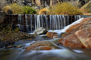
Overview: Short and easy walk down to the dam which is a local favorite area for a picnic or to play in Jacobson Creek. The dam is also the start of the off-trail Jacobson Canyon hike.
|
 Route Editor