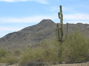
Maricopa Peak is the highest point of the Ma Ha Tauk range of South Mountain. At 2523 feet, it is the third highest peak on South Mountain, the highest being Mount Suppoa at 2690 feet, followed by Goat Hill at 2526 feet. The peak is accessed from Alta Trail at milepost 8. There is an obvious use trail leading up to the peak toward the east. The northern lobe of the peak rock formation is the highest point.
The posted GPS route is only for the spur trail from the Alta turnoff. Milepost 8 is roughly three miles from Bajada trailhead on the eastern end of Alta, or a mile and a half from San Juan trailhead on the west. San Juan road leads to both trailheads and is only open the first weekend of the month. Bajada Trail can be reached at any time by parking where the road is blocked off and walking.
The spur trail is faint but clear enough. Cactus, creosote and catclaw encroach at times. There are a couple of places you have to climb over rocks and there is a little bit of exposure. Nothing sketchy; just take your time. At the actual peak, there is a very minor scramble up rock to the high point on the left, or north. Great views of the valley, South Mountain, and the Estrellas are found. There is a nice flat summit area to take a break. The south part of the peak is worthy of exploration, too.
If you're going to hike Alta, a side trip to this peak offers a lot of value for only a half-mile out of the way. In my opinion, the best way to enjoy it is to hike from Bajada and return the same way. ( GPS track for that option )
WARNING! Hiking and outdoor related sports can be dangerous. Be responsible and prepare for the trip. Study the area you are entering and plan accordingly. Dress for the current and unexpected weather changes. Take plenty of water. Never go alone. Make an itinerary with your plan(s), route(s), destination(s) and expected return time. Give your itinerary to trusted family and/or friends.
Permit $$
None
Directions
Road
Connector trail - Not Applicable
To hike from the central avenue entrance at south mountain, go 2.5 miles on san Juan road bajada trailhead is on the left.
page created by trekkin_gecko on Nov 05 2012 3:01 pm
 Route Editor

 Maricopa Peak is the highest point of the Ma Ha Tauk range of South Mountain. At 2523 feet, it is the third highest peak on South Mountain, the highest being Mount Suppoa at 2690 feet, followed by Goat Hill at 2526 feet. The peak is accessed from Alta Trail at milepost 8. There is an obvious use trail leading up to the peak toward the east. The northern lobe of the peak rock formation is the highest point.