 Route Editor

| Guide | ♦ | 22 Triplogs | 0 Topics |
details | drive | permit | forecast | 🔥 route |
stats |
photos | triplogs | topics | location |
| 0 | 22 | 0 |
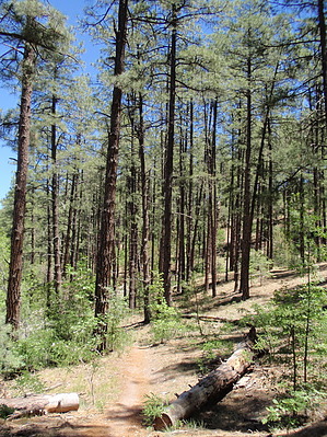
  Overview OverviewMiller Creek Trail #367 is part of a network of trails serving the Thumb Butte area. This trail begins in a Ponderosa Pine forest and parallels Miller Creek, a babbling stream that grows during the first weeks of spring when snowmelt trickles down from the surrounding high country. It is common to see Acorn Woodpeckers, nuthatches, and other woodland birds flitting from tree to tree. Because the terrain is gentle, this trail is an excellent option for introducing young children to hiking and the outdoors. This trail connects with other trails that can be combined to create a variety of loops. One suggested route, available to all non-motorized users, is to travel Trail #367 to Thumb Butte Bypass Trail #326. Take this trail to the southwest as it climbs to its junction with Garden Grove Trail #392. Miller Creek Trail #367 winds downhill back to the beginning. This loop covers roughly 3.5 miles.
Check out the Official Route and Triplogs. Leave No Trace and +Add a Triplog after your hike to support this local community. One-Way Notice This hike is listed as One-Way. When hiking several trails on a single "hike", log it with a generic name that describes the hike. Then link the trails traveled, check out the example. | ||||||||||||||||||||||||||||||||||||||||||||||||||||||||||||||||||||||||||||||||||||||||||||||||||||||||||||||||||||||||||||||||||||||||||||||||||||||||||||||||||||||||||||||||||||||||


