 Route Editor

| Guide | ♦ | 8 Triplogs | 0 Topics |
details | drive | permit | forecast | route |
stats |
photos | triplogs | topics | location |
| 89 | 8 | 0 |
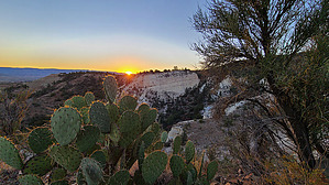
where casual hiker's go for a group cry by joebartels  Overview OverviewPronounced ree-all, Ryal Canyon Trail #521 is 2.5 miles long. It begins along the paved Salt Mine Road and ends at Box T Trail #511. A peek at satellite displays the intriguing white geology. I figured it was limestone but it is gypsum, salt, and clay. Hike Begin at the southwest corner of the trailhead. The double-track path is the trail. A ravine on your right surfaces at 0.1-mi and has your attention in earnest by 0.2-mi. Curiosity is the only thing getting a workout in the first quarter-mile with a subtle 100-ft gain.
0.5-1.8 mi Keep your foot on the gas and keep reaching for stars, but wait... the views are an excellent excuse to pause. The ridge gets narrow and dotted with Crucifixion Thorn. That irreplaceable bridge only lasts for ten to twenty yards. Geology in the first mile sings at sunrise. Water troughs are reached at 1.1, 1.7 and 2.1 miles, so it's unlikely you will die of thirst if you bring a filter. A black water tube follows the trail up and was in good repair by whoever tends the grazing cattle. I didn't see cattle near this trail, but there were signs of cow activity. At 1.78 miles the ridge portion of the hike ends. The trail bends south. Now skirting the slope of Ryal Canyon, the grade doesn't let up. You are out of the white soil and the slopes are dotted with small symmetrical junipers and prickly pear. The trail ends on rocky double-track at a junction with Box T Trail #511. It is a stone's throw down to Ryal Creek with a small bridge on #511 canopied by large trees. It was dry but a nearby spring on FS Topo is called Ryal Water. The only water here was at a round stock tank. Synopsis Seemingly light-used. Despised by casual strollers based on reports elsewhere. If I had not hiked it myself, I would have expected Everest. The 12.6% grade is relatively steady and lacks mammoth-sized steps found on Piestewa/Camelback with a third steeper grade. While it would not make my top 50 hikes, it was an unexpected treat. The tread is rocky in areas. The upper-end wrecks havoc on hikers looking for a hike en route to hors d'oeuvres and a splash of wine. History Intriguing details about Camp Verde Salt Mine and the geology are found on mindat.org, scroll down for two paragraphs. Gate Policy: If a gate is closed upon arrival, leave it closed after you go through. If it is open, leave it open. Leaving a closed gate open may put cattle in danger. Closing an open gate may cut them off from water. Please be respectful, leave gates as found. The exception is signage on the gate directing you otherwise. Check out the Official Route and Triplogs. Leave No Trace and +Add a Triplog after your hike to support this local community. One-Way Notice This hike is listed as One-Way. When hiking several trails on a single "hike", log it with a generic name that describes the hike. Then link the trails traveled, check out the example. | |||||||||||||||||||||||||||||||||||||||||||||||||||||||||||||||||||||||||||||||||||||||||||||||||||||||||||||||||||||||||||||||||||||||||||||||||||||||||


