 Route Editor

| Guide | ♦ | 10 Triplogs | 0 Topics |
details | drive | permit | forecast | 🔥 route |
stats |
photos | triplogs | topics | location |
| 116 | 10 | 0 |
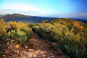
Sierra Prieta escalator by PrestonSands   Overview OverviewThe East Copper Trail #260 is located on the southern slopes of the Sierra Prieta, southwest of Prescott. This trail begins at Highway 89 and quickly ascends to the western shoulder of Mount Francis, near the summit of Copper Basin Road. In addition to the East Copper Trail, there is the option of connecting with the Aspen Creek Trail #48 and climbing 7110 foot Mount Francis for an even better view of the greater Prescott area. Hike From milepost 300.7 on Highway 89, walk downhill on Forest Road 53 for a tenth of a mile to the bottom of Copper Creek. A large sign for East Copper Trail greets you here, next to some large ponderosa pines. Turn right (east) onto the East Copper Trail, which begins climbing steeply up the east slope of the canyon along a multiple-use trail bed (hiker/horse/ohv). One-quarter of a mile in, at a small saddle, the pines give way to chaparral brush and occasional alligator junipers.
Two miles in and having gained some 1100 feet, East Copper leaves the ridges behind to head for the pine-filled basin in the distance. Passing a signed junction with Aspen Creek Trail #48, the East Copper Trail drops into the forested bottom of what one might call "East Copper Canyon". The trail continues its now gentler ascent through Gambel Oak and ponderosa pine in a pleasant, high mountain valley. East Copper Spring itself is passed as the trail climbs out of the valley towards its high point in a saddle on the west side of Mount Francis. Shortly beyond the high point saddle, East Copper Trail comes to an end at a locked gate along Mount Francis Road. Consider a half-mile side hike to the top of Mount Francis. It's worth the view. Water Sources East Copper Spring may have water. Camping The East Copper Spring area is likely the best spot along the entire trail for backpacking opportunities. Gate Policy: If a gate is closed upon arrival, leave it closed after you go through. If it is open, leave it open. Leaving a closed gate open may put cattle in danger. Closing an open gate may cut them off from water. Please be respectful, leave gates as found. The exception is signage on the gate directing you otherwise. Check out the Official Route and Triplogs. Leave No Trace and +Add a Triplog after your hike to support this local community. One-Way Notice This hike is listed as One-Way. When hiking several trails on a single "hike", log it with a generic name that describes the hike. Then link the trails traveled, check out the example. | ||||||||||||||||||||||||||||||||||||||||||||||||||||||||||||||||||||||||||||||||||||||||||||||||||||||||||||||||||||||||||||||||||||||||||||||||||||||||||||||||||||||||||||||||||||||


