 Route Editor

| Guide | ♦ | 38 Triplogs | 0 Topics |
details | drive | permit | forecast | 🔥 route |
stats |
photos | triplogs | topics | location |
| 273 | 38 | 0 |
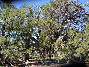
Jekll & Hyde by MEWhiteman   Overview OverviewThis is a scenic trail with views in many directions through well-shaded pine and oak forest for the first half and scrub for the second half. Reroutes in recent years have made the trail longer than the description in Ron Smith's book A Guide to Prescott and Central Highlands Trails, 3rd edition, which I used when planning the hike. The hike can be done as an out & back which is pretty strenuous if you do the whole hike (12 miles, 3,000 AEG) or as a one-way with a car shuttle (easiest from north to south). Hike Park in the Aspen Creek trailhead parking area which has room for about 8-10 cars. When I did this hike, the lot was full, but there was parking along the unpaved road nearby to the east. The trail begins at a fiberglass trail marker for trail #48 across from the parking area. This first part of the trail is relatively new and is a pleasant, shady walk. It goes by some interesting large rocks and meets FR 9401L after about 0.6 miles (N34 30.009 W112 31.538). Stay on #48 and at 0.8 miles into the hike you pass a junction with Wolverton Mountain Trail #9415 N34 29.885 W112 31.424. Once past this point trail #48 becomes a single track leaving civilization behind with views of the Bradshaw Mountains, Sierra Prieta Range, and even the San Francisco Peaks in the distance at a different point along the trail. The mountain with all the radio towers to the northwest is Mt. Francis. At about 2.1 miles into the hike, you go through a gate, and at 2.9 miles in you'll come upon a very large alligator juniper at N34 28.907 W112 31.923. This is the largest specimen of one that I have ever seen to date. This is also the highest point on the hike; it is downhill in both directions from here.
Trail #260 from trail #48 to FR 53 is unshaded giving great views, but the trail itself was not very interesting. Staying on #260 from this point the trail heads continuously down and at 4.6 miles passes a mine on the right (N34 27.839 W112 32.011). Trail #260 ends in 6.1 miles at FR 53 (N34 27.379 W112 32.238). The entire section of #260 from the mine to FR 53 has been rerouted in recent years making it longer than in the past but also ending it close to AZ89, making a car shuttle very feasible. If you parked your car at the Aspen Creek trailhead and don't have a shuttle, its a tough climb back to the alligator juniper and then some rolling ups and downs back to the car. As I was tired, I took a shortcut back by following FR 9401L from its junction with trail #48 back to Copper Basin Road, saving about 0.5 miles. Gate Policy: If a gate is closed upon arrival, leave it closed after you go through. If it is open, leave it open. Leaving a closed gate open may put cattle in danger. Closing an open gate may cut them off from water. Please be respectful, leave gates as found. The exception is signage on the gate directing you otherwise. Check out the Official Route and Triplogs. Leave No Trace and +Add a Triplog after your hike to support this local community. One-Way Notice This hike is listed as One-Way. When hiking several trails on a single "hike", log it with a generic name that describes the hike. Then link the trails traveled, check out the example. | |||||||||||||||||||||||||||||||||||||||||||||||||||||||||||||||||||||||||||||||||||||||||||||||||||||||||||||||||||||||||||||||||||||||||||||||||||||||||||||||||||||||||||||||||||||||||||||||||


