Overview
Short spur trail that drops off the main Willow Springs #223 to a dependable spring in the western Mazatzal Wilderness.
Hike
The start of this trail is 6.8 miles from the western end of Willow Springs #223, on a shallow saddle right before a hefty climb. The junction is marked with an old sign and cairn, though the post may be knocked over. It heads southeast along the side of a ridge for a short distance, passing through brush and a few short trees.
At 0.2 miles it reaches the end of the ridge, switching back and forth a few times as it drops 200' and crosses a shallow drainage on the way to Horse Creek. Two appealing campsites show up above the creek and then the foliage around Willow Spring shows up, narrowing the route to a narrow path between lush grass with branches hanging low. This is effectively the end of the trail - once you're done with the spring and/or camp areas, return up the hill to continue on your larger adventure.
Water Sources Willow Spring is the cleaner of two water sources along Horse Creek and Willow Springs #223, making this spur trail well worth the mild elevation drop needed to get to it.
Camping
At least two campsites are located on the bank of Horse Creek above the spring, one along the trail and exposed to the open air and the other a bit more tucked under the trees.
When hiking several trails on a single "hike", log it with a generic name that describes the hike. Then link the trails traveled, check out the example.
WARNING! Hiking and outdoor related sports can be dangerous. Be responsible and prepare for the trip. Study the area you are entering and plan accordingly. Dress for the current and unexpected weather changes. Take plenty of water. Never go alone. Make an itinerary with your plan(s), route(s), destination(s) and expected return time. Give your itinerary to trusted family and/or friends.
Permit $$
None
Directions
Road
FR / Jeep Road - Car possible when dry
To Sheep Bridge Trailhead Take Cave Creek road east and follow the directions to Seven Springs - Cave Creek Road turns into FR24. Take FR24 35 miles until it ends at FR269. Take FR269 another 12 miles to the southeast until it ends at Sheep Bridge. NOTE: the last 8 miles or so of FR269 is unmaintained! While it may be passable by car - I would urge something with more clearance and designed suspension.
From PHX (I-10 & AZ-51) 105mi 3h 38m From TUC (Jct 1-10 & Grant) 182mi 4h 50m From FLG (Jct I-17 & I-40) 119mi 3h 44m
 Route Editor


 Overview
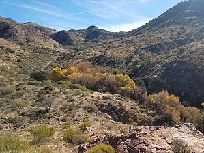


