 Route Editor

| Guide | ♦ | 31 Triplogs | 2 Topics |
details | drive | no permit | forecast | 🔥 route |
stats |
photos | triplogs | topics | location |
| 220 | 31 | 2 |
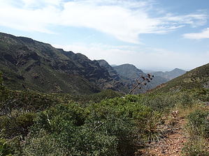
Ascend into the Mad-as-Ells by jacobemerick   Overview OverviewThis is one of the most challenging long-distance trails of the Mazatzal Wilderness. Reaching the trailhead is an ordeal, the first few miles are a hot and dry slog, and the last half was demolished by wildfire. The solitude and expansive views of the central wilderness, especially of Midnight Mesa and Deadman Creek, are well worth the effort. Sections of this trail can make a good loop (see Sheep Bridge / Mountain Spring Loop for example), as hiking end-to-end is an uncommon feat. Warning Much of this trail is within the Willow Fire burn. In particular, the eastern half (starting at the Midnight Mesa Trail junction) was hit hard and much of it is overgrown and washed out to the point of obliteration.
If you survive the drive out to Sheep Bridge, park, and cross the bridge on foot, taking some time to read up on its history and check out the old foundations. The start of the trail is located about 500 yards along the Verde River Trail, shortly after it crosses Horse Creek and starts heading north. There is a short climb to a good view back on the Verde River before the doldrums begin. The first few miles is a flat desert, with prickly pear, gnarled trees, and various types of scrubby brush. Some sections are straight as an arrow while others twist around mean vegetation. Trying to figure out where the trail climbs the eastern hills may provide some distraction during this slog. At 3.5 miles there are a few washes to cross and the vegetation begins to green up some, and things become progressively nicer as the trail follows a shallow ridge and plays near Horse Creek. At 5.6 miles there is a sudden climb up a little drainage to officially mark the end of the boring flat section. The spur trail of Willow Spring #244 shows up at 6.8 miles, with a pleasant and dependable spring located at the end. This could make for a nice breakfast spot before a serious climb over the next few miles. After the spur, there is a quick 1200' gain over 1.6 miles, which first follows a ridge with great views to both sides, then switches back and forth up a steep hillside, then pops over a shallow saddle. Fire damage begins to become apparent during this section, with plenty of skeletal trees and minor deadfall to deal with. Excellent views are plentiful during this climb. Beyond the shallow saddle, the trail dips down into a little valley, first swinging along the side of red-rock 5193' and then dropping down to the side of Horse Creek at the junction with Deadman Trail #25. This valley is a pleasant, grassy change from the rocky hills. At 9.2 miles there is an unnamed spur that leads over to Mountain Spring, which is worth the short jaunt over. This spring is dependable and has nearby camping options, plus some of the biggest, greenest trees in the area. To continue east, there is a short jaunt north along Dutchman Grave before a second junction w/ Willow Springs. Just remember that you want to continue east, up the side of the valley, and it should be easy to figure out. A 650' climb is needed to get out of the valley, with a few nice switchbacks to ease up the grassy hillside. There is a short drop on the other side before a second spur trail, Lost Spring #279, although this trail does not have a pleasant spring at the end. Past this junction is another climb, this one less than 300', through a sad forest of burned trees, that ends up on a narrow ridge with a great vista into Deadman Creek to the east. At 11.4 miles the trail swings alongside Midnight Mesa on a narrow path - be sure to stay on track, as hacking a way across this steep side would be difficult. Midnight Mesa passes by quickly and the trail descends a short way to the Midnight Trail #272 junction. This is where serious overgrowth starts to show up. The tread is all but gone here and a mixture of willow and manzanita cluster along the ridge where a discernible trail once led. Follow the ridge for about a mile, keeping the shallow tributary of Wet Bottom Creek on the left and the much deeper and more impressive valley of North Fork Deadman Creek on the right, swinging around to the north before things get too steep. At 13.2 miles the trail finally crosses the Wet Bottom tributary, follows a sandy wash for a bit, and then starts to climb. The next hill to climb is 6351' which, like its almost-anagram to the west, is composed of red rocks and has a lot of dead, burned trees on the slopes. At least the trail, which had all but disappeared for a while, makes a comeback here, and there is good tread and cairns to track as it switches back and forth a few times. When it crests the climb at 14.2 miles things become grassy and difficult to follow again as it swings along the side of the summit, not quite hitting the peak. Once east of 6351' the trail hops on top of a ridge/series of small hills, which are mostly clear of brush and deadfall and have a handful of cairns to help guide across. Looking across Maverick Basin gives a great view of a ridge that few get to experience. Manzanita takes over at 15.6 miles and the rest of the hike is rough. As of 2018, there was no tread or path to follow, just a fight through brush that is often over six feet tall, with the occasional deadfall or boulder wash-out to struggle over. Before the fire this was likely a pleasant stroll through tall pines, now it's relentless. Once through this section you can stumble over to Pete's Pond for some well-earned water and rest. Water Sources Willow Spring is located near the trail, just down a short spur about 7 miles east of Sheep Bridge, and Mountain Spring shows up a few miles later. Other water sources (Lost Spring, Wet Bottom Creek tributary) are seasonal at best. Pete's Pond is located about 0.5 miles beyond the eastern end of the trail. Camping Mountain Spring is the best campsite along the trail. There are some options near Willow Spring as well. At the east end of the trail is The Park, which is conveniently located at the junction of North Peak and Mazatzal Divide Trails and is near Pete's Pond. Check out the Official Route and Triplogs. Note This is a moderately difficult hike. Leave No Trace and +Add a Triplog after your hike to support this local community. One-Way Notice This hike is listed as One-Way. When hiking several trails on a single "hike", log it with a generic name that describes the hike. Then link the trails traveled, check out the example. | ||||||||||||||||||||||||||||||||||||||||||||||||||||||||||||||||||||||||||||||||||||||||||||||||||||||||||||||||||||||||||||||||||||||||||||||||||||||||||||||||||||||||||||||||||||||||||||||||||||||||||||||||||||


