 Route Editor

| Guide | ♦ | 73 Triplogs | 0 Topics |
details | drive | no permit | forecast | 🔥 route |
stats |
photos | triplogs | topics | location |
| 506 | 73 | 0 |
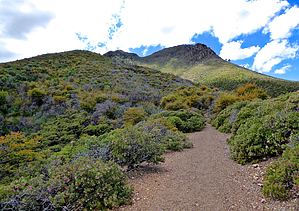
Swinging around Saddle Mountain by jacobemerick   Overview OverviewA curving trail that follows the contours of Saddle Mountain and nearby hills. An integral part of AZT #22 and, thanks to the relative accessibility of Mormon Grove Trailhead, the start of many long loops into the north and west. It ends with an overgrown loop that goes by some old mining areas. History Much of this area was damaged by the 2012 Sunflower Fire.
Mormon Grove is an open spot perched on a ridge that offers great views to the south and east. The trail heads west and wastes little before climbing, gaining 100' in less than a quarter-mile, before calming down and even dropping a bit to the Little Saddle Mountain Trail junction at .6 miles. This junction is well signed and has some pretty rock formations in the background. Now part of the AZT, the trail heads north and makes a steady climb towards Saddle Mountain. Along the way, it zigs and zags along the side of 5888, alternating between offering good views of the surrounding lands and protective drainages for a few large trees that were spared from fire. This section is overall pleasant and easy to travel if the steady climb doesn't wear too much on one's legs. The last outward zag shows off a now-overbearing Saddle Mountain before the trail swings towards Potato Patch and the end of the uphill grade at 1.9 miles. A side spur branches to the west towards Potato Patch, a grassy clearing with some camping options along the fringes, and the main trail swings northeast and plays along the side of the mountain. Some of the in-and-out swings along the side of Saddle Mountain are quite drastic, though the views down the different drainages to the east are lovely. At 3.4 miles, the junction with Sheep Creek Trail shows up, and the AZT follows that, leaving the final leg of this trail with less traffic and maintenance. The final leg forms a lasso loop, with the end being the trail junction and the loop of it being very overgrown. At 3.5 miles, the loop starts - turn left to do it clockwise. After it curves around near Story Mine, things get the most overgrown with catclaw (I gave up finding the mine after fighting this lovely stuff). Things clear up on the other side of the loop, and the last few hundred yards to close the lasso is reasonably simple. Water Sources None along the trail. Continuing on Sheep Creek Trail will take you to McFarland Canyon and a reliable water source. Camping Potato Patch has several spots for camping, as does McFarland Canyon a mile beyond the northern terminus of the trail. Check out the Official Route and Triplogs. Leave No Trace and +Add a Triplog after your hike to support this local community. One-Way Notice This hike is listed as One-Way. When hiking several trails on a single "hike", log it with a generic name that describes the hike. Then link the trails traveled, check out the example. | ||||||||||||||||||||||||||||||||||||||||||||||||||||||||||||||||||||||||||||||||||||||||||||||||||||||||||||||||||||||||||||||||||||||||||||||||||||||||||||||||||||||||||||||||||||||||||||||||||||||||||||||||||||||||


