Overview
Of the three trails that start from Deer Creek Trailhead, Gold Ridge Trail is the only one that stays out of a heavily vegetated (and often difficult to follow) creek and does not cross into the Mazatzal Wilderness. This trail is mostly on an exposed ridge, follows an old road for part of the way, and isn't technically closed to wheeled/motorized traffic, making it one of the more passable routes in the area. It can be combined with South Fork Trail for a solid loop or Deer Creek Trail for longer adventures.
Hike
From Deer Creek Trailhead, head down South Fork Trail about 0.4 miles to the start of Gold Ridge Trail. There is a trail sign here, plus a well-trod path and helpful cairns to guide you through a grassy pasture. Good chance there'll be some cattle roaming around here as well. At 1.0 miles there is a gate to pass through - please make sure to close it behind you - and then the climb begins.
Over the next mile and a half, the ridge gains 1400', with few switchbacks or breaks to ease the way. There are some sections of loose rock, too, to up the difficulty a bit. Vegetation is mostly low manzanita that does little to block the sun yet does provide some good views to distract from the climb. At the top of this section there is a morale-boosting view back down to the trailhead.
There is still elevation to gain, though now it is done more gently. The trail winds around some hills and crosses some saddles and slowly gains ground. At 3.0 miles the trail takes advantage of an old road and becomes much easier to walk on. More views began to open up, including some great angles of the Mazatzal Mountains in the north and a few brief glimpses of Mt Ord / Four Peaks / Roosevelt Lake to the south. Eventually, the trail swings up a small hill and ends on FR 3348. Turn right on the road to connect with FR 201 and other trails along it.
Water Sources
None on the trail. Pigeon Spring is the closest, over on South Fork.
Camping
There is a fantastic car-camp site at the top of Gold Ridge Trail, as well as some additional flats along FR 3348.
Gate Policy: If a gate is closed upon arrival, leave it closed after you go through. If it is open, leave it open. Leaving a closed gate open may put cattle in danger. Closing an open gate may cut them off from water. Please be respectful, leave gates as found. The exception is signage on the gate directing you otherwise.
When hiking several trails on a single "hike", log it with a generic name that describes the hike. Then link the trails traveled, check out the example.
WARNING! Hiking and outdoor related sports can be dangerous. Be responsible and prepare for the trip. Study the area you are entering and plan accordingly. Dress for the current and unexpected weather changes. Take plenty of water. Never go alone. Make an itinerary with your plan(s), route(s), destination(s) and expected return time. Give your itinerary to trusted family and/or friends.
Permit $$
None
Directions
Road
Paved - Car Okay
To hike To Deer Creek Trailhead:
Take AZ-87 to Deer Creek Trailhead, which is located directly across from the AZ-88 intersection. Trailhead is a basic lasso structure, just park along the side where there is space. Cattle may be grazing nearby / on the dirt lot.
From PHX (I-10 & AZ-51) 70mi 1h 10m
From TUC (Jct 1-10 & Grant) 170mi 2h 40m
From FLG (Jct I-17 & I-40) 110mi 2h 10m
 Route Editor


 Overview
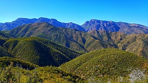


