 Route Editor

| Guide | ♦ | 2 Triplogs | 0 Topics |
details | drive | permit | forecast | 🔥 route |
stats |
photos | triplogs | topics | location |
| 5 | 2 | 0 |
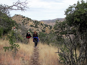
Not very devilish by kwpapke   Short hike up-canyon from Rucker Rd. to Bruno Saddle. Follows a well-used and fertilized cowpath. The good-news: the path is easy to follow. The bad news: constant cowpie dodging. Short hike up-canyon from Rucker Rd. to Bruno Saddle. Follows a well-used and fertilized cowpath. The good-news: the path is easy to follow. The bad news: constant cowpie dodging.The first 1/2 mile crosses the seasonal stream bed, then climbs up the side of the canyon enough to afford some nice views. Pleasant & constant views of the rock outcroppings, then a pleasant view to the South once Bruno Saddle is reached.
It seems possible to make this a loop hike with a car shuttle if the North Bruno trail #237A is added, but we had only one vehicle so did an out-and-back. The FS description also calls out a spur trail to Rucker Peak. We did not see the spur. The map shows it about 1/2-way up the canyon, which might be describing an area where a large watering hole was formed by damming the stream. However, the text description on the FS site indicates the spur starts at the end of the Devil's Canyon trail at Bruno Saddle, and we did not see evidence of it. The continuation to North Bruno was obvious and well-marked. We did this as a Christmas Eve Day outing from Douglas, and it made for a pleasant morning. Coronado FS Details The Devil's Canyon/North Bruno Trail system offers access into an area of remote canyons, odd rock formations and bluff-faced peaks on the south end of the Chiricahua Mountains. Devil's Canyon, so far as anyone knows, is so named because the pinnacles, needles and balanced rocks that form its canyon walls resemble distorted human forms. The trail leaves Rucker Canyon Road and heads up-canyon, under the watchful eye of these devil rocks, as it wanders its way among riparian stands of sycamore, willow and ash. This vital streamside habitat provides an excellent place to enjoy a little birdwatching and perhaps catch a glimpse of some larger wildlife before the trail leaves the canyon floor to begin its gradual climb, through oak and juniper, to Bruno Saddle. From Bruno Saddle, a side trail (Rucker Peak Trail #601) leads to Rucker Peak's 7,136 foot summit, one of the highest in the southern Chiricahuas. The main trail continues from the saddle down into North Bruno Canyon. Here, it follows the riparian area to the junction with the North Bruno Trail #237A. This latter trail connects the Devil's Canyon Trail to a trailhead off the Rucker/Tex Canyon road, FR 74, at the end of FR 4818. From the Devil's Canyon/North Bruno trail junction one can choose to head up North Bruno Canyon and end the journey, or continue down North Bruno Canyon to explore more of this remote area. The North Bruno Trail ends at a junction with a 4-wheel drive road at the confluence of North and South Bruno Canyons. There is, however, no public vehicular access to this point. Check out the Official Route and Triplogs. Leave No Trace and +Add a Triplog after your hike to support this local community. One-Way Notice This hike is listed as One-Way. When hiking several trails on a single "hike", log it with a generic name that describes the hike. Then link the trails traveled, check out the example. | |||||||||||||||||||||||||||||||||||||||||||||||||||||||||||||||||||||||||||||||||||||||||||||||||||


