Route Editor

| Guide | ♦ | 57 Triplogs | 0 Topics |
details | drive | permit | forecast | route |
stats |
photos | triplogs | topics | location |
| 136 | 57 | 0 |
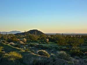
Not Spooky at All! by chumley   Just because it's on the internet does not make it true! Just because it's on the internet does not make it true!Facts and Truth Despite what popular online sources might say, this is NOT Spook Hill. It is NOT Spook Hill Mountain Preserve. The City of Mesa has confirmed to me that there is no such thing as Spook Hill Mountain Preserve! According to the most recent information from the Maricopa County Assessor's office (the people who collect taxes and therefore have every reason to know the truth), this mountain is divided into numerous parcels of PRIVATE LAND. It is NOT public land. It is NOT a park. It is NOT a preserve! (The actual "Spook Hill" is a prominent hill located in the middle of the Las Sendas neighborhood just east of the intersection of Power and Thomas Roads, about 3 miles NE of Brown Peak.) With all those facts out there, I'm still posting this because it is used frequently by local residents for a quick hike, workout, or just a nice place to get good views of northeast Mesa. Please obey any posted signs. The current landowners either allow public use or are "turning a blind eye" to it. Landowners can change at any time. If new signage prohibits use, please obey the signage, and please post a comment on this page to alert other users of the change.
This peak does not have an official name that I can find in any historical record. It seems strange that a prominent bump in the desert-like this would be nameless when surrounded by other similarly prominent bumps that do have names, including Double Knolls, Spook Hill, Raven's Roost, Thunder Mountain, and Stone Mountain. History This mountain was once the home to a microwave tower of some kind. There is an old foundation for a tower at the top, and there are three portions of the mountain that have been graded to a perfectly flat surface devoid of vegetation. I have been unable to determine when the towers were removed, or what purpose they served when they stood. But it was the microwave tower that facilitated the building of the dirt road that serves as the hiking trail to the top (closed to vehicles). When the microwave tower stood, it was called the Spook Hill Microwave Tower ... but not because it was actually ON Spook Hill, just because it covered the Spook Hill region of northeast Mesa. Because the microwave tower was registered with the FCC, the evil Google extracted the name from official government publications and incorrectly assigned the name to the hill rather than recognizing that the tower was not named for the hill it stood on but for the region its transmissions covered. So now that's all cleared up... The Hike The road is short and steep. It is washed out and rutted. Local residents might want to hike or run this 2 or 3 times for a proper workout because it is less than half a mile to the summit, and should take 10-15 minutes at most. But it does climb 300 feet in that distance, so you will get your heart pumping if you want to! The main views are from the southwest corner of the peak, though there is a slightly lower viewpoint in the southeast corner. A very overgrown and eroded road leads down to an even lower area on the northwest corner. If you are doing a repetitive workout, just head up and back, but if this is a once in a while exploration with kids or visitors, you may want to explore all three view spots (as shown in the official GPS track). I wouldn't recommend this as a destination hike. Head for the nearby Usery Mountains or the Superstitions for that. I would think that only somebody who lives nearby would consider this climb. Or perhaps somebody who has driven by it so many times that the curiosity of bagging this peak could no longer be ignored. Check out the Official Route and Triplogs. Leave No Trace and +Add a Triplog after your hike to support this local community. | |||||||||||||||||||||||||||||||||||||||||||||||||||||||||||||||||||||||||||||||||||||||||||||||||||||||||||||||||||||||||||||||||||||||||||||||||||||||||||||||||||||||||||||||||||||