Route Editor

| Guide | ♦ | 4 Triplogs | 0 Topics |
details | drive | no permit | forecast | 🔥 route |
stats |
photos | triplogs | topics | location |
| 49 | 4 | 0 |
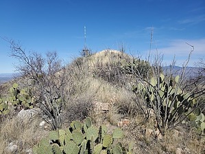
Not the Roman Empire, but only Kings and Queens can make it to the top by Mike_W  Overview OverviewThe Empire Mountains are about 30 miles southeast of Tucson and stretch northeast from the Santa Rita Mountains and include several well-known mining properties, including the Total Wreck Mine, the Montana Mine, and the Hilton Group Mines. The Empire Mountains high point has an elevation of 5,588 feet and it's a total bushwhack to get to the summit. If you attempt to climb this you will need to dodge some catclaw bush, ocotillo, and a few patches of prickly pear. There's one major false summit on the way up. Once there you will need to continue north for about 1/4 mile across a rocky ridgeline to get to the summit. Hike Start by bushwhacking northeast. In the first 1/4 mile, you'll need to carefully hike around or between some catclaw vine, ocotillo, and prickly pear. The brush wasn't too thick when I hiked it in January. During other times of the year, it may be thicker. After hiking 1/4 mile you will feel like you're on the wrong ridgeline, but don't worry. After hiking a total of 0.4 miles you'll see a way to easily cross over to the ridge to your east without having to go down into a gully. Cross over to the main ridge and keep heading up to the high point which is a false summit. You'll likely need to zig-zag a bit.
Looking to the northeast and slightly lower you will see a National Weather Service antenna. Looking East and down you will see some private property that is part of Hilton Ranch, looking southwest you will see the Santa Rita mountains, and looking to the west you will see Mt. Fagan. In January, Mt. Wrightson and some of the higher peaks were snow-covered. To get down, retrace your route back the same way. Watch out for the grassy areas which may be slippery. Don't forget to cross back over to the secondary ridge where you started from. Check out the Official Route and Triplogs. Leave No Trace and +Add a Triplog after your hike to support this local community. | ||||||||||||||||||||||||||||||||||||||||||||||||||||||||||||||||||||||||||||||||||||||||||||||