 Route Editor

| Guide | ♦ | 35 Triplogs | 0 Topics |
details | drive | permit | forecast | 🔥 route |
stats |
photos | triplogs | topics | location |
| 271 | 35 | 0 |
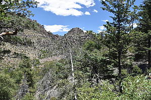
Leisurely Canyon Walk by markthurman53   CHIRICAHUA NATIONAL MONUMENT CHIRICAHUA NATIONAL MONUMENTChiricahua National Monument is on the north side of the Chiricahua Mountains in the Southeast corner of Arizona. About as far southeast as you can go in Arizona without being in New Mexico or Mexico. This is almost a fairy tale land of Rock spires, pinnacles, balanced rocks, and hoodoos where the laws of gravity don’t seem to apply. Although the park road traverses the park, to fully enjoy this park requires getting out of the car and hiking some of the 17 miles of trails. All the trails in the park are in excellent condition and well signed. This 12000-acre park was established on April 18, 1924, to preserve the park's natural wonders of weathered volcanic tuff. In 1934 during the great depression, the CCC built the park buildings, many of which still exist today. The many park trails throughout the park today were also constructed by the CCC. Before the monument's 1880s existence, the area was settled by ranchers and, prior to that, the Apaches. The monument has displays on the history, plants, and animals of this unique environment.
If you don’t mind the 2-hour drive from Tucson, Chiricahua Monument is a great place to visit and hike the scenic packed trails. This is relatively remote, so usually not crowded. The four or five times I have been there less than 50 visitors, and at least two of the times less than four cars in the park, and one of them was a park ranger (During the COVID thing). LOWER RHYOLITE CANYON TRAIL The Lower Rhyolite Canyon Trail starts at the Monument Visitor Center, about 2.5 miles from the park entrance. Rhyolite Canyon comes in from the east and joins Bonita canyon at this point. Lower Rhyolite Canyon Trail heads up Rhyolite Canyon along the south side of the Creek slowly gaining elevation until at the end of the trail 1.5 miles later at the Sarah Deming and Upper Rhyolite Canyon Trail junctions. At this point, it is 120 feet above the creek bed. The trail is primarily forested with Cedar and pine and since it is on the north-facing side of the canyon offers protection from the sun. The Rhyolite cliffs are about 200 feet up above the trail and can be seen across the canyon along Rhyolite Creek. There are no grand rock formations along this trail but it is the western entrance to the other trails that head up into the rock formations. This trail offers excellent views to the west over Bonita Canyon and the park entrance and up stream into Upper Rhyolite canyon with its cliffs of Rhyolite on either side. Since this is the only trail that enters from the west there are no true loop trails from this trail but there are many options for in and back lollipop hikes. Check out the Official Route and Triplogs. Leave No Trace and +Add a Triplog after your hike to support this local community. One-Way Notice This hike is listed as One-Way. When hiking several trails on a single "hike", log it with a generic name that describes the hike. Then link the trails traveled, check out the example. | |||||||||||||||||||||||||||||||||||||||||||||||||||||||||||||||||||||||||||||||||||||||||||||||||||||||||||||||||||||||||||||||||||||||||||||||||||||||||||||||||||||||||||||||||||||||||||||||||||||||||


