 Route Editor

| Guide | ♦ | 21 Triplogs | 0 Topics |
details | drive | permit | forecast | 🔥 route |
stats |
photos | triplogs | topics | location |
| 169 | 21 | 0 |
Upper Rhyolite Canyon Views by markthurman53   CHIRICAHUA NATIONAL MONUMENT CHIRICAHUA NATIONAL MONUMENTChiricahua National Monument is on the north side of the Chiricahua Mountains in the Southeast corner of Arizona. About as far southeast as you can go in Arizona without being in New Mexico or Mexico. This is almost a fairy tale land of Rock spires, pinnacles, balanced rocks, and hoodoos where the laws of gravity don’t seem to apply. Although the park road traverses the park, to fully enjoy this park requires getting out of the car and hiking some of the 17 miles of trails. All the trails in the park are in excellent condition and well signed. This 12000-acre park was established on April 18, 1924, to preserve the park's natural wonders of weathered volcanic tuff. In 1934 during the great depression, the CCC built the park buildings, many of which still exist today. The many park trails throughout the park today were also constructed by the CCC. Before the monument's 1880s existence, the area was settled by ranchers and, prior to that, the Apaches. The monument has displays on the history, plants, and animals of this unique environment.
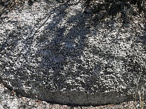
If you don’t mind the 2-hour drive from Tucson, Chiricahua Monument is a great place to visit and hike the scenic packed trails. This is relatively remote, so usually not crowded. The four or five times I have been there less than 50 visitors, and at least two of the times less than four cars in the park, and one of them was a park ranger (During the COVID thing). HAILSTONE TRAIL The Hailstone Trail has no accessible trailhead except via other trails. Access is gained via the Upper Rhyolite and Echo Canyon from the West and Ed Riggs Trail from the East. From the east side at the Ed Riggs Trail, this 0.8-mile trail is a gradual 143 foot mostly downhill hike. This trail makes a good interconnecting trail as part of two shorter loop hikes, one being a loop to the north via Echo Canyon the other being a little longer loop to the south along the Balanced Rock and Sarah Deming Trails. Even though this is not a long trail, it is packed with lots to see. There are great views down Rhyolite Canyon and Totem and Hunt Canyons to the south. The rock spires along this trail are quite impressive, and it may take you longer to do this 0.8 miles trek because of all the stopping for sightseeing. I believe the trail gets its name from the small hailstone size rocks found along the central part of this trail. While I can’t say for sure this is the only place in the park I have seen these rocks; they are definitely abundant here. The Hailstone Trail is on the south-facing slope of Rhyolite Canyon; therefore, a little more sun exposure with fewer trees and more shrubs. Check out the Official Route and Triplogs. Leave No Trace and +Add a Triplog after your hike to support this local community. One-Way Notice This hike is listed as One-Way. When hiking several trails on a single "hike", log it with a generic name that describes the hike. Then link the trails traveled, check out the example. | |||||||||||||||||||||||||||||||||||||||||||||||||||||||||||||||||||||||||||||||||||||||||||||||||||||||||||||||||||||||||||||||||||||||||||||||||||||||||||||||||||||||||||||||||||||||||||||||||||||||||


