Route Editor

| Guide | ♦ | 13 Triplogs | 0 Topics |
details | drive | permit | forecast | route |
stats |
photos | triplogs | topics | location |
| 108 | 13 | 0 |
It's a mother! by chumley   What might otherwise be called the Mummy Mountain Ridgeline Extravaganza was given the name "Mummy Lode" in honor of its much bigger Four Peaks sibling. To be fair, this doesn't come close to the extremities of the Mother Lode, but it's about as much fun that you can have in the middle of town. Who knew that this little bump in the middle of Paradise Valley could result in 4+ hours of scrambling, a few crazy climbs, some surprising exposure, 4000 feet of AEG :o , great views, and just a little bit of Peeping Tom creepiness into the backyards and picture-window bathtubs of the upper classes? What might otherwise be called the Mummy Mountain Ridgeline Extravaganza was given the name "Mummy Lode" in honor of its much bigger Four Peaks sibling. To be fair, this doesn't come close to the extremities of the Mother Lode, but it's about as much fun that you can have in the middle of town. Who knew that this little bump in the middle of Paradise Valley could result in 4+ hours of scrambling, a few crazy climbs, some surprising exposure, 4000 feet of AEG :o , great views, and just a little bit of Peeping Tom creepiness into the backyards and picture-window bathtubs of the upper classes?This is an A+ adventure, and I can't believe it doesn't get more use. There are obvious routes that have been traveled before, but there is no route, rarely a cairn, and another person? Not to be seen!
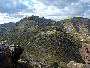
From the summit, follow the ridgeline north, dropping down to a saddle before climbing up to a surprisingly large Peak 2233 (really just about 30 feet short of the main summit). From 2233, head east, just to bag the lower peak too. Note that you will leave public land and enter private property upon reaching the saddle below 2233 and the lower peak. Please obtain the necessary permission or trespass at your own risk. Next, you will continue along the northern ridgeline. Instead of returning to 2233, head north, down the chute from the saddle, and turn west to traverse the hillside toward the next saddle. Again, please be aware that the ridgeline in this area is on private property. The climb up peak 1936 is steep and exposed and requires some short climbs when you follow the true ridgeline or the east side. You can bypass the climbing by swinging around to the west side, but the terrain is steep and scree-covered. I think it's easier and safer to stay on solid rock and climb. Just west of 1936 is a secondary peak made largely of bright white quartz. From 1936, continue to descend along the ridgeline to the next saddle before climbing up to Peak 1807, marked on the map as Mummy Mtn Observatory. This peak offers lovely views of north Phoenix and a great perspective of the route you just hiked. From here, return the way you came, or cut the corner and take the direct route back up to 2233 on a very steep slope that will most certainly wear you out! It's about 1.5 miles from 1807 back to the summit, depending on your exact route. If you've had enough, head back down to the trailhead for a total hike of about 4 miles. Otherwise, do the east ridge too! From the summit, head down the east ridge, where you will encounter the first of 3 fun (sketchy?) spots! Find your way down and continue. Views of Camelback from this ridge are great! Parts of this ridge have been accessed from the various homes and roads on the south side of the ridge, and use is occasionally evident. You descend to a small saddle that had some "brick art" as of this writing. From there, ascend to peak 1956. Descending 1956 leads to a very steep, exposed downclimb. You can bail to the dirt road to the south, but it's crazy steep and scree, so I think the climb is easier and safer. And way more fun!! From the dirt lot at the end of the road, you must again cross a section of private property. Proceed at your own risk. The next two mini-peaks along the ridge are public, but the third is private. From here, the ridge drops down to the paved terminus of Invergordon Road, crossing it at the driveway of a private residence before leading up to a flattened lot at the end of the road (closed). A water tank sits just below this point and marks the preserve land's end (preserved, but still private property). I don't recommend proceeding beyond the water tank since the ridgeline continues down until it actually crosses over the roof of a house built into the hillside. Here you may encounter guard dogs, security, armed homeowners, etc. So, the point here is... turn around at the water tank. Head back up the ridgeline 1.3 miles back to the summit before descending to the trailhead parking lot. Drive home feeling a little sore but wearing a huge grin wondering why you've never done this before. NOTICE *Please be aware that this hike begins on the private property of the Camelback Inn Resort. Ask permission before parking or hiking if you are not a hotel guest. Parts of this route cross privately held preserve land. Enter private land only after obtaining permission to do so or at your own risk. 100% of this route is off-trail scrambling. THERE IS NO TRAIL!!! Check out the Official Route and Triplogs. Note This is a more difficult hike. It would be unwise to attempt this without prior experience hiking. Leave No Trace and +Add a Triplog after your hike to support this local community. | ||||||||||||||||||||||||||||||||||||||||||||||||||||||||||||||||||||||||||||||||||||||||