Route Editor

| Guide | ♦ | 24 Triplogs | 0 Topics |
details | drive | no permit | forecast | route |
stats |
photos | triplogs | topics | location |
| 9 | 24 | 0 |
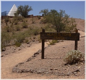
Desert Pyramid by joebartels  Get on the trail and head on up. Circle the pyramid and read the plaque. If you get tired there are benches for resting. Gather up your gear and head on back. Get on the trail and head on up. Circle the pyramid and read the plaque. If you get tired there are benches for resting. Gather up your gear and head on back.Okay, so this is hardly a trail worth mentioning, right! I'd ridden by this little funky pyramid on my bike several times. To me, it was just an old beat-up-looking something or other. I figured it was some playground thing from the sixties that was never completed. It was one of those things you wondered about for about ten seconds and then moved on. It wasn't until I hiked the Ellison Creek area near Payson that I became interested. I was curious about the Ellison name as everything in Payson seems to have history involved in the names. Anyhow, I'm reading along at the Scottsdale library about this tomb. ...only to find out I'd ridden my bike by it on the way to the library! It's still nothing exciting. However, it does have a certain 'neatness (hey that's kinda neat)' to me now. Check out the Official Route and Triplogs. Leave No Trace and +Add a Triplog after your hike to support this local community. | |||||||||||||||||||||||||||||||||||||||||||||||||||||||||||||||||||||||||||||||||||||||||||||||||||||||||||||||||||||||||||||||||||||||||||||||||||||||||||||||||||||||||||||