Route Editor

| Guide | ♦ | 17 Triplogs | 0 Topics |
details | drive | no permit | forecast | 🔥 route |
stats |
photos | triplogs | topics | location |
| 286 | 17 | 0 |
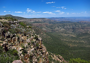
.. XXXXXXXXXXXXXX .. by Grasshopper   Overview OverviewLocated just outside the SSW boundary of our Sierra Ancha Wilderness, this moderate off-trail hike to this dominant Benchmark Peak which looms in the distance very visible from various Sierra Ancha hiking trails and destinations. Its most interesting accessible scenic east and SE rugged cliffs with near and distant views within the wilderness area offers scenic opportunities from numerous plateau viewpoints. Warning Precautions should be considered for hiking during our Arizona monsoon season due to open exposure for possible lightning strikes. Also, it should be noted that this author has listed in the "official" GPS Route two optional TH Starts for this hike- a lower TH Start and an upper TH Start but all posted hike description stats are based on a hike start and end from the lower TH Start (the upper TH Start is based on driving from the lower TH to the upper TH. This authors assumption is that ~95% of our hiking population interested in this summit hike, would not qualify for driving their vehicle the required three (3) serious, modified 4WD vehicle miles up FR489 to reach the upper TH Start.. please also see additional comments posted in the "Driving Directions" section).
There is a significant amount of historic Asbestos mining history around and included within the first 2.5 miles of this Zimmerman Point 6871 summit hike. It is highly recommended to review our HAZ Asbestos Point hike description for all the interesting details. Hike This hike begins at the recommended lower TH Start at the intersection of Hwy288/FR489 and proceeds for 2.5 miles up nicely tree-shaded, but steep and loose-rocky/rutted FR489 where it connects with a joining spur road (at 6341ft.. 33.760216 -110.943232) heading first southerly then NE for an additional 0.50 miles to end at the "Official" GPS Route labeled upper TH Start location (at 6411 ft.. 33.759232 -110.938631). This upper TH Start location is the beginning of the ~1.8 miles "off-trail" R/T hike segment to the summit, explore, and return from Zimmerman Point 6871. It is recommended that you download and follow the Official Route. The first 0.25 "off-trail" miles basically follows the path up of least resistance dodging vegetation and dodging a pesky old deteriorating barbed-wire ranching fence which seems to be determined to follow the best hiking path up for a significant distance. It is necessary to cross over this old ranching fence a few times but if you are following the recommended GPS Route it will take you through the easier crossover locations on your way up and back down. As you make your way up in altitude with the vegetation lower, numerous short and long-distance scenes open up around you in all directions but north for some great scenic photography options. Once arriving at the larger and flatter than expected BM summit area, you will not initially see much is the scenic distance, but after visiting the summit area make your way over to the ENE cliff edges to view numerous plateau points for some most awesome Sierra Ancha views south, east, and north. Water Sources Pocket Creek drainage is seasonal with Pocket Spring being a perennial spring just off the hiking route along FR489. Camping If you have the right 4WD vehicle and are experienced in this type of 4WD road, then there are some great vehicle camping options in this area below Asbestos Point summit. Backpacking options also abound but are probably not that popular in this area. Check out the Official Route and Triplogs. Leave No Trace and +Add a Triplog after your hike to support this local community. | |||||||||||||||||||||||||||||||||||||||||||||||||||||||||||||||||||||||||||||||||||||||||||||||||||||||||||||||||||||||||||||||||||||||||||||||||||||||||||||||||||||||||||||||||||||||||||||||||||||||||||||