Route Editor

| Guide | ♦ | 9 Triplogs | 0 Topics |
details | drive | no permit | forecast | 🔥 route |
stats |
photos | triplogs | topics | location |
| 39 | 9 | 0 |
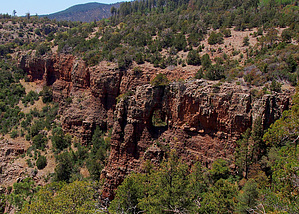
 Overview OverviewThis hike on the Sierra Ancha Rim Trail #139, accessed from the Carr Trailhead, takes you to an off-trail segment on the rim overlooking a small but deep side canyon on the north side of upper Coon Creek Canyon. The original objective of this hike was to look for possible ancient Indian cliff dwellings in the cliff walls of this side canyon. Although no clear evidence of any Indian ruins was found, the rugged beauty of this deep canyon viewed from the rim above was well worth the hike. A bonus was finding a large 20-30 ft high natural window in the canyon cliff wall with daylight and a large pine tree visible through the window. A loop was made out of this hike by taking an off-trail route cross country from the rim trail to FR487. This return route takes you uphill through a tall pine forest, a short section of New Mexico Locust thorn bushes/trees, and across lightly forested meadows to the road. Warning The off-trail return route of this hike has exposure to thorny New Mexico Locust. Long sleeves and pants, and gloves are highly recommended. An alternative to avoid the thorns is to return via the trails or to make a long loop hike by continuing on Rim Trail #139 to the Moody Pt Trail and taking that trail back to FR487, then hiking along the road back to the Carr TH (see the following link).
This hike starts at the Carr TH at 7050 ft elevation on FR487, the road up Workman Creek Canyon. This road is normally closed in the winter until March 31 at the Workman Creek Falls campground and possibly later due to winter road damage or late-season snowstorms. Car camping sites past Workman Creek Falls are limited, but there are several pullouts with existing fire rings. The Carr TH is the upper trailhead for the Parker Creek Trail #160, which this hike follows downhill for 0.8 miles to its intersection with the Rim Trail #139. Views of the upper end of Coon Creek Canyon are seen along the way. This part of the hike passes through an area that experienced extensive damage from the April 2000 Coon Creek Fire. There appears to have been a forest of large Pine trees in the area near the trail intersection, with only a few survivors and many dead snags left standing. Fallen charred logs litter the ground. The trail has been restored to good condition, and the forest is in full recovery. From the intersection with TR160, follow the Rim Trail for 1.5 miles southeast to the first off-trail portion of this hike. This short off-trail section goes 0.3 miles south along the west rim of a small but deep side canyon on the north side of upper Coon Creek Canyon. Off-trail hiking is fairly easy, with plenty of openings for detours around clumps of manzanita. High cliff walls with many alcoves and several small caves, possible sites for ancient Indian ruins, are visible along the west-facing walls on the opposite side of this canyon. From here, the hike goes back to the Rim Trail, following it east 0.4 miles to the next off-trail segment. The second off-trail takes you south for 0.3 miles along the south rim of a fork in this deep side canyon. This area was relatively untouched by the Coon Creek Fire and is forested with tall pine trees and huge Junipers. There are views of the south-facing high cliffs with numerous alcoves and a large window through one section of the cliff with a tall pine tree visible through the window. This would be a favored southern exposure for ancient Indian ruins, so some time was spent scanning the cliffs with binoculars and telephoto camera lens. We opted to go north off-trail for 0.9 miles to FR487 for the return route making this a loop hike. This off-trail section quickly gains elevation climbing a hillside forested with tall pine trees mostly untouched by the Coon Creek Fire. Thickets of thorny New Mexico Locust threaten to block your passage near the crest of the hell. We followed a planning track carefully plotted on Google earth to find a clear path through this obstacle. Unfortunately, we accidentally deviated from this path and ended up in the middle of a dense thicket of thorny stuff. We forged ahead, cutting back towards the planning track rather than backtrack. After thrashing through the thorns for about 150 yds, we got back on track in an area with tree-like mature New Mexico Locust, which was spaced widely enough apart to allow easy passage. I recommend following our planning track rather than following our actual track where we deviated from the plan to minimize contact with the nasty thorns. After cresting the top of the hill, the route enters a lightly forested lush meadow that gently slopes down to FR487. This area looks like a prime area for deer and elk, which was verified by the presence of a hunting stand in a tree beside a well-traveled game trail. After reaching the road, it's a 0.8-mile walk back to the Carr TH. Check out the Official Route and Triplogs. Leave No Trace and +Add a Triplog after your hike to support this local community. | |||||||||||||||||||||||||||||||||||||||||||||||||||||||||||||||||||||||||||||||||||||||||||||||||||||||||||||||||||||||||||||||||||||||||||||||||||||||||||||||||||||||||||||||||||||||||||||||||||||