Route Editor

| Guide | ♦ | 54 Triplogs | 0 Topics |
details | drive | no permit | forecast | route |
stats |
photos | triplogs | topics | location |
| 397 | 54 | 0 |
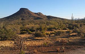
Nice loop with a peak by Booneman  This new trail in the Northern section of the McDowell Sonoran Preserve takes you clockwise around (and to the summit of) Brown's Mountain, starting from Brown's Ranch trailhead. Follow the rolling Upper Ranch trail for approximately 1.9-2.0 miles until you reach Brown's Mountain trail, which is where the climb begins to reach the saddle at 2.4 miles. A short, steeper 0.2-mile section will take you to the summit at 3,253ft offering expansive views of the North valley. The descent takes you down the South side of the mountain on Brown's Mountain trail 1.4 miles back to the trailhead. This new trail in the Northern section of the McDowell Sonoran Preserve takes you clockwise around (and to the summit of) Brown's Mountain, starting from Brown's Ranch trailhead. Follow the rolling Upper Ranch trail for approximately 1.9-2.0 miles until you reach Brown's Mountain trail, which is where the climb begins to reach the saddle at 2.4 miles. A short, steeper 0.2-mile section will take you to the summit at 3,253ft offering expansive views of the North valley. The descent takes you down the South side of the mountain on Brown's Mountain trail 1.4 miles back to the trailhead.Brown's Mountain is somewhat unique in that the trail takes you to the peak, unlike most trails in the preserve. The area also has a great deal of history regarding the Brown family and ranching in the early 1900s. This newly opened section of the preserve (June 2013) offers over 50 miles of trails well-suited to hikers, mountain bikers, riders, and runners. Even though the trails are very well marked, be sure to pick up a map at the trailhead (provided free of charge), and bring plenty of water as the trails are completely exposed to the sun. Check out the Official Route and Triplogs. Leave No Trace and +Add a Triplog after your hike to support this local community. | |||||||||||||||||||||||||||||||||||||||||||||||||||||||||||||||||||||||||||||||||||||||||||||||||||||||||||||||||||||||||||||||||||||||||||||||||||||||||||||||||||||||||||||||||||||