Route Editor

| Guide | ♦ | 20 Triplogs | 0 Topics |
details | drive | permit | forecast | route |
stats |
photos | triplogs | topics | location |
| 79 | 20 | 0 |
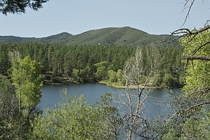
  Park at the Lynx Northshore parking lot. Begin by taking Lynx Spillway Trail #445 north. Turn right onto Highlands Trail #442, and then right onto Gold Pan Trail #444. You will exit Trail 444 on the road to the Gold Pan area. Here you will find bathroom facilities. Follow the road until you get to a gate. Here you will turn right onto Salida Connection Trail #9263. Proceed through a gate and turn right onto Salida Gulch Trail #95. From here it is about 3/4 mile to some petroglyphs. In about 3/4 mile you will turn right onto Johns Tank Trail #94 which takes you back to the parking lot crossing over Lynx Lake Dam. Park at the Lynx Northshore parking lot. Begin by taking Lynx Spillway Trail #445 north. Turn right onto Highlands Trail #442, and then right onto Gold Pan Trail #444. You will exit Trail 444 on the road to the Gold Pan area. Here you will find bathroom facilities. Follow the road until you get to a gate. Here you will turn right onto Salida Connection Trail #9263. Proceed through a gate and turn right onto Salida Gulch Trail #95. From here it is about 3/4 mile to some petroglyphs. In about 3/4 mile you will turn right onto Johns Tank Trail #94 which takes you back to the parking lot crossing over Lynx Lake Dam.Gate Policy: If a gate is closed upon arrival, leave it closed after you go through. If it is open, leave it open. Leaving a closed gate open may put cattle in danger. Closing an open gate may cut them off from water. Please be respectful, leave gates as found. The exception is signage on the gate directing you otherwise.
Check out the Official Route and Triplogs. Leave No Trace and +Add a Triplog after your hike to support this local community. | |||||||||||||||||||||||||||||||||||||||||||||||||||||||||||||||||||||||||||||||||||||||||||||||||||||||||||||||||||||||||||||||||||||||||||||||||||||||||||||||||