 Route Editor

| Guide | ♦ | 21 Triplogs | 0 Topics |
details | drive | permit | forecast | route |
stats |
photos | triplogs | topics | location |
| 221 | 21 | 0 |
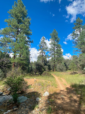
Exit where you Enter by joebartels   Overview OverviewThe loop begins and ends 0.1-mi up Salida Connection Trail #9263 from Salida Gulch Trailhead. Clockwise is the easier direction of travel. Salida is exit, output, or way out in Spanish. Warning Salida Gulch has a decent-sized catch to create a quick-flowing creek in heavy rainfall. Staying dry is unlikely and it may be dangerous.
We hiked this counterclockwise to knock out the steeper grade in the cool morning with fresh legs. This lower trail in the range and being near a trailhead gets more use than higher-up trails Prospectors Trail #42 and Salida Trail #93. While there is minor rocky tread, the tread on this trail is much better than those two trails. Ponderosa Pines are best in the first and last 0.5-mi. Since the loop is narrow, it's easy to create a 1-mi loop cutting through the forest 150-170 feet. It appears to be fairly easy open Ponderosa forest on satellite. 0.5 to 1.85-mi to Johns Tank Trail #94 is pinyon with a mix of scrub chaparral of some sort. I didn't give it much attention because it wasn't out for blood. I netted one whopping scratch in a larger 16-mile hike with the previously mentioned trails. From square one, it is a 400-ft ascent to the highpoint just before John's Tank Trail on the NE side of 5802. The 200-ft of off-trail to 5802 looks like uninviting scrub vegetation based on satellite. John's Tank is soon after and a stone's throw from the trail. I didn't see it but it looks easy enough on satellite to check it out. 1.85 to 3.5-mi has a light mix of Ponderosa Pines. 2.65 to 3.0-mi is a nice area but not as nice as that first half-mile. From 2.65-mi on you cross the creekbed umpteen times so you will not be staying dry if it's recently rained heavy. There is a void of ponderosas but you're gradually descending and the final 0.3-mi is a walk through paradise. There is rock art along the way which gets some excited, you can't miss it unless you're staring at your feet. Camping A couple of nice options. However, the package deal will not appeal to the masses. Synopsis We hiked #95 on a 16-mi figure eight of sorts. There was some bellyaching on #93 and it seems unlikely I'll be returning soon if ever. It is a nice brush-free loop with a couple of sweet spots.
Check out the Official Route and Triplogs. Leave No Trace and +Add a Triplog after your hike to support this local community. One-Way Notice This hike is listed as One-Way. When hiking several trails on a single "hike", log it with a generic name that describes the hike. Then link the trails traveled, check out the example. | ||||||||||||||||||||||||||||||||||||||||||||||||||||||||||||||||||||||||||||||||||||||||||||||||||||||||||||||||||||||||||||||||||||||||||||||||||||||||||||||||||||||||||||


