Overview
This trail can be accessed from the end of FR 538 on the rim or as an add-on to the Loy Canyon Trail. The trail climbs up from the Secret Mountain Saddle where it joins with the Loy Canyon Trail. Because of the remoteness and infrequent use of the trail, the trail can be easily lost. Several trail spurs take the hiker to spectacular views but pay attention to where you left the main trail. There is only one way to return and that is the way in. If you lose the trail, retrace your steps immediately to pick up the trail again.
Red Rock Wilderness
This collection of cliffs, buttes, and canyons has to rank as one of nature's most magnificent masterpieces. It certainly is one of the most colorful. Red is the predominant hue here among these 43,950 acres of wind and water sculpted pinnacles, windows, arches, and slot canyons. The area is crisscrossed with trails that take you everywhere from the deepest gorges to the most prominent panoramas. Along these pleasant paths, you'll discover wonders made both by nature and by some of the area's earliest human inhabitants. Watch the canyon walls and high cliffs for rock art and abandoned dwellings as diligently you keep an eye to the horizons for vistas and breathtaking overlooks.
As you part the chaparral to emerge into a hidden grotto or clamber up a slick rock slope to a dizzying precipice, you may even experience the unmatched thrill that you could have been the first to see whatever you've stumbled upon. One thing you'll surely rediscover here among the manzanita and red rocks is your sense of wonder.
When hiking several trails on a single "hike", log it with a generic name that describes the hike. Then link the trails traveled, check out the example.
WARNING! Hiking and outdoor related sports can be dangerous. Be responsible and prepare for the trip. Study the area you are entering and plan accordingly. Dress for the current and unexpected weather changes. Take plenty of water. Never go alone. Make an itinerary with your plan(s), route(s), destination(s) and expected return time. Give your itinerary to trusted family and/or friends.
Permit $$
None
Red Rock - Secret Mountain Wilderness see map for camping restrictions
 Route Editor


 Overview
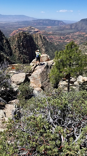


