username
X
password
register
for free!
help
  

Cam-Boh Trail, AZ

Guide 23 Triplogs  0 Topics
  2.3 of 5  
Fav
Wish
0
details
drive
permit
forecast
route  
stats
photos
triplogs
topics
location
7 23 0
Statistics
tap row or icons for details
Difficulty 1 of 5
Route Finding 1 of 5
Distance One Way 2.35 miles
Trailhead Elevation 2,401 feet
Elevation Gain 160 feet
Accumulated Gain 178 feet
Avg Time One Way 1.75 hours
Kokopelli Seeds 2.94
 Backpack No
 Dogs not allowed
feature photo
Photos Viewed All MineFollowing
6  2025-03-15
Wash Me Now
fricknaley
10  2023-10-03
SNP West
markthurman53
4  2021-02-27
Ironwood Forest Trail - Saguaro NP West
chumley
3  2019-12-22
Cam-Boh Trail
coyotek
21  2017-09-27
Panther Peak Prophecy Wash Loop
markthurman53
6  2017-09-22
Cam-Boh Trail central Saguaro NP
markthurman53
7  2008-10-25 fricknaley
Author
author avatar Guides 93
Routes 397
Photos 4,984
Trips 4,124 map ( 27,424 miles )
Age 49 Male Gender
Location Tucson, AZ
Associated Areas
list map done
Tucson Region
Historical Weather
Trailhead Forecast
Radar Map
Expand Map
Preferred Jan, Dec, Feb, Nov
Seasons   Autumn to Spring
Sun  6:02am - 6:44pm
Official Route & 2 Rts
 
5 Alternative


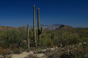
Do'h...it's the Cam-Boh
by fricknaley

Background
There is nothing particularly memorable about the Cam-Boh trail. It's just a level ramble through the desert to a picnic area. It connects the eastern and western ends of the northern foothills and desert area of Saguaro West national park. It parallels the road to some degree. It also offers excellent desert views and vegetation and is very close and easy to get to. For these reasons, it has its merits.


Hike
From the ubiquitous Ringtail Trailhead off Picture Rocks road, cross the street and take off on the wide sandy beginning of the Ringtail trail. Within 0.1 miles you come to a signed intersection for the Cam-Boh trail to your right. Take this and head west. The trail parallels the Picture Rocks road for the majority of the trip, which takes a couple of cool points off...but hey you know that going in. The beginning of Cam-Boh follows the path of a relatively narrow sandy wash. Within 0.4 miles you come to the first intersection of this trail, the Ironwood Forest trail heads left. Stay straight on your way. Soon thereafter, the trail breaks out of the wash and just rambles rather flatly through the desert. There is all manner of nice cacti around. Looking north you start to have nice views of Sombrero Peak and the flat Peak 3263 ridgeline. Looking back east Picture Rocks and Contzen Pass look sweet and you have great views of Mt. Lemmon through the pass (you'll see it the whole way back...one of the highlights of the hike). Looking south you can see Wasson Peak looking over the foothills.
remove free decal offer
A mile from the Ironwood Forest will bring you to the intersection for the Panther Peak Wash trail, which breaks off to your right. Again stay straight. You can now see Panther Peak to the north and the Sombrero Peak ridgeline running west. In a total of 0.6 miles from Panther Peak Wash, you will come to the gravel Golden Gate Road which cuts into the heart of the park and leads to the Esperanza trailhead among others. Cross over the road and pick up the Cam-Boh trail again, which keeps on running diligently to the west. In a quick 0.3 miles the signed, wide, and sandy Prophecy Wash trail breaks off to the left and runs south towards Wasson Peak. From here you cross a couple of smaller washes before dead-ending at the Cam-Boh picnic area, built by the CCC in the '30s. It's a nice little picnic spot out in the desert. Head back the way you came for a quick and easy 5+ mile walk.

2008-10-26 fricknaley
  • Rincon HAZ Map
    area related
    Rincon HAZ Map
  • Rincon Mountain Distric East
    area related
    Rincon Mountain Distric East
  • Tucson Mountain District West
    area related
    Tucson Mountain District West
  • SNP Cactus Forest Map
    area related
    SNP Cactus Forest Map
  • nps related
  • sub-region related


Check out the Official Route and Triplogs.
Leave No Trace and +Add a Triplog after your hike to support this local community.

One-Way Notice
This hike is listed as One-Way.

When hiking several trails on a single "hike", log it with a generic name that describes the hike. Then link the trails traveled, check out the example.
WARNING! Hiking and outdoor related sports can be dangerous. Be responsible and prepare for the trip. Study the area you are entering and plan accordingly. Dress for the current and unexpected weather changes. Take plenty of water. Never go alone. Make an itinerary with your plan(s), route(s), destination(s) and expected return time. Give your itinerary to trusted family and/or friends.

 Permit $$
NPS

Saguaro National Park
2022 $25 vehicle • $20 motorcycle • $15 individual on foot or bicycle
Receipt is valid for 7 days
$45 Annual Park Pass View All

No fee required from Miller Creek Trailhead off Mescal Rd.


 Directions
or
 Road
Paved - Car Okay

To hike
From Tucson take exit 246 off I-10 and go west on Cortaro until it ends at a T. Turn right here onto Ina for a short distance, then Left onto Wade. Wade quickly becomes Picture Rocks Road and crosses through the Tucson Mountains. You'll see a couple of signs announcing Saguaro National Park. As you come down the west side of the mountains the road swings hard to the right and there is a paved pull-out area to the right. Park here. The trails take off just across the street.
page created by fricknaley on Oct 26 2008 12:38 pm
 90+° 8am - 6pm kills
helpcorrectionissue

end of page marker