Route Editor

| Guide | ♦ | 4 Triplogs | 0 Topics |
details | drive | no permit | forecast | 🔥 route |
stats |
photos | triplogs | topics | location |
| 0 | 4 | 0 |
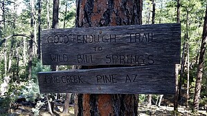
it's good enough for me by alexandy   This is a short, one and a half mile round trip, trail in the Tonto National Forest. The trail is not an official Forest Service trail and is not shown on any maps that I have seen. Regardless, the trail is fairly well-marked and maintained. This is a short, one and a half mile round trip, trail in the Tonto National Forest. The trail is not an official Forest Service trail and is not shown on any maps that I have seen. Regardless, the trail is fairly well-marked and maintained.The hike starts adjacent to a residential area in the community of Pine at the western end and intersects with the Pine Canyon Trail #26 as its eastern terminus. To start the hike, go through and close the gate of the fence that separates the National Forest from the homes along the forest boundary. The gate is directly east and within twenty feet of the end of Manzanita Drive. In the beginning, the trail goes through a thinned-out Ponderosa forest, with numerous wood piles. The cutting was done to provide a fire protection barrier for the adjoining homes. Continuing east, the forest becomes denser. Much of the trail follows a drainage uphill and has switchbacks, which are marked with cairns.
Gate Policy: If a gate is closed upon arrival, leave it closed after you go through. If it is open, leave it open. Leaving a closed gate open may put cattle in danger. Closing an open gate may cut them off from water. Please be respectful, leave gates as found. The exception is signage on the gate directing you otherwise. Check out the Official Route and Triplogs. Leave No Trace and +Add a Triplog after your hike to support this local community. | ||||||||||||||||||||||||||||||||||||||||||||||||||||||||||||||||||||||||||||||||||||||||||||