Route Editor

| Guide | ♦ | 1 Triplog | 0 Topics |
details | drive | no permit | forecast | 🔥 route |
stats |
photos | triplog | topics | location |
| 54 | 1 | 0 |
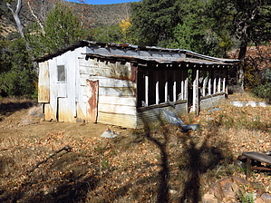
Shortcut to 'Shay by CannondaleKid   Overview OverviewThe hike is shortcut version of Del Shay Trail #41. Instead of starting from the north and the 12.8-mile round-trip hike, this hike begins from Forest Road 1938 on the ridge above Del Shay Basin and adds up to a mere 2.0 miles. Warning About 20% of this hike (nearest the cabin) follows an old road, but it is made up of many loose rocks, so you may want to walk alongside it for safety. The rest of the hike is definitely off-trail, but with careful route selection, you should be able to avoid the worst of the thick and thorny vegetation. Or better yet, follow the official GPS route as I took the best of two routes to save you the time, distance, and trouble of backtracking.
The gravel road from Punkin Center up FR71 & FR609 to the FR1938 junction can be driven by a car when dry. On Forest Road 1938, you could drive the first mile or so with a 2WD pickup or SUV when dry, but after that, you WILL need a 4x4 with good clearance. If the first 1/8 mile is muddy, DO NOT CONTINUE by vehicle. Hike it on foot and add 10 miles round-trip to the 2-mile hike. NOTE: The farther you travel on FR1938 the more extensive the Arizona Pinstripes your vehicle WILL acquire! History Preston did such a fine job of the history of the area in the hike description for Del Shay Trail #41 that I have nothing to add. If you're interested, check it out! Hike From the large rock cairn immediately adjacent to FR1938, you head slightly right to where the fence is low enough to step over, then back left to the next large cairn, then turn northwest and set off. With careful observation, you will find bits and pieces of what was likely a trail some years ago, but with so much elk and deer traffic, it's easy to get fooled and wander until you hit a dead-end of thick brush. After about a quarter-mile, you will approach an outcropping of rock, seemingly too much of a drop to climb down. If you follow the official GPS track, you will find the one easy spot to drop down where you will continue northwest until you reach the drainage. Turn left, follow the drainage until it gets too thick, climb the slope to the right, then continue slightly north of west until connecting with the old road and follow it down to the cabin. If you are NOT following the official GPS track and don't want to waste time attempting to find another way down the rock outcropping, I would recommend keeping well to your left and follow the drainage until the next outcrop where you will take a sharp right and traverse across the slope to the north to the next drainage. From there, continue as noted in the previous paragraph. Water Sources Seasonal at Del Shay Cabin. Camping You may camp at Del Shay Cabin, but I wouldn't recommend staying inside the cabin. We had a beautiful campsite adjacent to Forest Road 1938 within 50 yards of the trailhead. Even during hunting season, over four separate days, I was out here, I did not encounter one other person along FR1938, so you truly feel alone! If you want to experience a deafening silence, this is where you want to be. Check out the Official Route and Triplog. Leave No Trace and +Add a Triplog after your hike to support this local community. | |||||||||||||||||||||||||||||||||||||||||||||||||||||||||||||||||||||||||||||||||||||||||||||||||||||||||