 Route Editor

| Guide | ♦ | 5 Triplogs | 0 Topics |
details | drive | permit | forecast | route |
stats |
photos | triplogs | topics | location |
| 89 | 5 | 0 |
Llewelyn's Litigation by chumley   Private Property Notice: Private Property Notice:First things first. The land in the area of South Peoples Spring is private property. Access to this part of Peoples Canyon requires written permission from the landowner. Contact information for the landowner can be obtained from the BLM Kingman Field Office. Warning: There are no developed trails in the Arrastra Mountain Wilderness. All travel is off-trail and requires careful route-finding and caution. This is a severe desert climate and this remote location can be dangerous at any time of year, but especially so in the warm summer months. Be prepared.
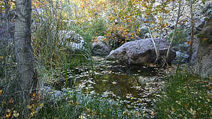
This is the shortest route to access the rugged South Peoples Spring area of Peoples Canyon. As of the time of this writing, there continues an ongoing legal dispute between the owner of the property at South Peoples Spring and the BLM regarding improved access and ranching needs. There is no reason to address details here, but it may be worth your time to research the facts if you plan to visit the area and will be contacting the landowner for permission to hike across the property. You will also likely encounter evidence of the dispute along your hike. Hike: The hike begins at the closed metal gate of what was once an old road leading toward the spring. A sign on the gate reminds users of the private property ahead. After about a quarter-mile and a short climb, the route follows the old road across mostly flat terrain, with just a few light rolling hills with little elevation change. Though Arrastra was only designated a wilderness in 1990, this road is often lost in the landscape, either eroded or overgrown. For the most part, it is easy to follow, but attention must be paid, or getting a bit off track is possible. Luckily, this desert landscape is forgiving, with widely spaced flora, easily traversed without obstacles. At about 1.8 miles you will reach a large above-ground water tank (empty, and no longer in use), before climbing a gentle slope to the high point of the hike. It is at this point, about 2.0 miles from the trailhead that you begin the 500-foot descent into Peoples Canyon. The old road down this hill has been severely eroded over time, and in some places, it is difficult to follow and you must just find your own route. About halfway down the hill, you will encounter a private property sign at a nice viewpoint, though my map indicates the property boundary actually occurs a bit farther up the hill (see official GPS route for details). Please respect private property and don't proceed beyond the sign without obtaining permission from the landowner. The bottom half of the road continues to deteriorate until it ceases to exist. An old irrigation pipe follows a cut in the hillside making the final descent to the canyon bottom where you will encounter thick brush, shady trees, and a trickling creek with a few deep pools of clear, cold water. The most interesting features are a bit upstream, but you can continue downstream and fight the thick riparian growth for over half a mile before it dries up, and becomes easier to explore. From here, you can return the way you came, head up canyon via the Peoples Canyon route, or head down canyon 3.5-4.0 miles to connect to the Santa Maria River. Gate Policy: If a gate is closed upon arrival, leave it closed after you go through. If it is open, leave it open. Leaving a closed gate open may put cattle in danger. Closing an open gate may cut them off from water. Please be respectful, leave gates as found. The exception is signage on the gate directing you otherwise. Check out the Official Route and Triplogs. Leave No Trace and +Add a Triplog after your hike to support this local community. One-Way Notice This hike is listed as One-Way. When hiking several trails on a single "hike", log it with a generic name that describes the hike. Then link the trails traveled, check out the example. | ||||||||||||||||||||||||||||||||||||||||||||||||||||||||||||||||||||||||||||||||||||||||||||||||


