Route Editor

| Guide | ♦ | 8 Triplogs | 0 Topics |
details | drive | permit | forecast | route |
stats |
photos | triplogs | topics | location |
| 34 | 8 | 0 |
Canyons are inherently risky. Flash floods occur without notice on sunny days. Technical skills & surrounding topography knowledge required yet does not eliminate risk.
Wapner's Verdict by chumley  Private Property Notice Private Property NoticeFirst things first. The land in the area of South Peoples Spring is private property. Access to this part of Peoples Canyon requires written permission from the landowner. Contact information for the landowner can be obtained from the BLM Kingman Field Office. Warning There are no developed trails in the Arrastra Mountain Wilderness. All travel is off-trail and requires careful route-finding and caution. This is a severe desert climate and this remote location can be dangerous at any time of year, but especially so in the warm summer months. Be prepared.
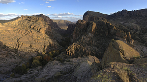
This route travels along an old overgrown mining road from the northern edge of the Arrastra Mountain Wilderness boundary, heading southward and up a gentle 100-foot climb before dropping steadily into Peoples Canyon. The old roadbed ends after about 1.5 miles and travel continues down-canyon on your own route. At about 1.6 miles, you encounter a shady grove of Sycamore trees, and as the canyon narrows pools of water appear. This is Sycamore Spring. There is no obvious spring source, but the existence of the large trees indicates ample groundwater, and it is a consistent source of surface water year-round. BLM Wilderness areas permit cattle grazing and this spring is reasonably accessible so it is likely that you will encounter cattle (or signs of them) in this area. This section of tree-filled narrow canyon continues for about a quarter-mile before the terrain changes as the canyon dries out again. The next 2+ miles is spent heading down canyon along portions of sandy wash, boulder-hopping, and large swaths of carved stone slabs. The travel is relatively easy compared to many off-trail canyon hikes in Arizona. Travel at or above 1mph is not unreasonable. The landscape surrounding the canyon changes as you proceed, offering differing views as you go along. There is not much shade in this part of the canyon, and the canyon walls are wide and of a moderate slope, so sun exposure can be a problem during hot weather. At about 4.2 miles you encounter another riparian area, South Peoples Spring, marked by large Sycamore, Cottonwood, and Willow trees. Pools of water begin to appear and shortly develop into a lightly flowing stream cascading through carved channels in the rock. It is approximately at this point that the canyon enters private property. Proceeding downstream from here requires the permission of the landowner. The canyon narrows here once again, and travel becomes increasingly difficult through thick bushes, and some more scrambling is required over and around large boulder obstacles. At about the 4.5-mile mark you encounter the terminus of the shortest hiking route to South Peoples Spring. Downstream of this point, the canyon is difficult to travel in due to water, pools, small cascades, and thick vegetation. After about another half mile, the bulk of the water retreats underground and the travel becomes easier. This description does not address the 3.5-4.0 miles of Peoples Canyon from South Peoples Spring to the Santa Maria River, but this section can also be hiked with few obstacles. Check out the Official Route and Triplogs. Leave No Trace and +Add a Triplog after your canyon trip to support this local community. | |||||||||||||||||||||||||||||||||||||||||||||||||||||||||||||||||||||||||||||||||||||||||||||||||||||||||||||||||||||||||||||||||||||||||||||||||||||||||||||||||||||||||||