username
X
password
register
for free!
help


Frye Mesa Reservoir, AZ

Guide 8 Triplogs  0 Topics
  3.7 of 5  
Fav
Wish
1
details
drive
permit
forecast
map
stats
photos
triplogs
topics
location
90 8 0
Statistics
tap row or icons for details
Trailhead Elevation 4,974 feet
 Interest Perennial Waterfall
unreported if dogs are allowed
editedit > ops > dogs to adjust
feature photo
Photos Viewed All MineFollowing
11  2022-04-21 cactuscat
6  2021-03-21
Frye Canyon Trail #36
chumley
44  2015-09-15
Frye Creek Canyon - S'mores
outdoor_lover
15  2013-12-09 SkyIslander18
14  2011-11-07 SkyIslander18
Author
author avatar Guides 16,843
Routes 17,472
Photos 24
Trips 1 map ( 6 miles )
Age 28 Male Gender
Location HAZ, TrailDEX
Historical Weather
Trailhead Forecast
Expand Map
Sun  5:56am - 6:40pm
0 Route
 
0 Alternative


remove free decal offer

 
Guide Needed
Publish Full Detail Guide


Use +Add above to share photos and triplogs
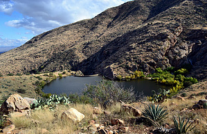
Frye Mesa Reservoir holds Rainbow, Brown, Brook & Gila trout.

Happy

Trails!


    Check out the Triplogs.
    Leave No Trace and +Add a Triplog after your fishing to support this local community.
    WARNING! Hiking and outdoor related sports can be dangerous. Be responsible and prepare for the trip. Study the area you are entering and plan accordingly. Dress for the current and unexpected weather changes. Take plenty of water. Never go alone. Make an itinerary with your plan(s), route(s), destination(s) and expected return time. Give your itinerary to trusted family and/or friends.

     Permit $$
    None

    Coronado Forest
    MVUMs are rarely necessary to review unless mentioned in the description or directions
    Coronado Motor Vehicle Use Maps (MVUMs)


     Directions
    or
     Road
    High Clearance possible when dry

    To fishing
    From the highway 70/highway 191 junction in Safford, head west on highway 70 for 3.75 miles to Reay Lane in Thatcher, AZ. Turn south onto Reay Lane (milepost 335.65) and follow it for 1.2 miles. At the 1.2 mile point, there will be an unmarked dirt road to the right (west) just before the auto wrecking yard. Turn right (west) onto this dirt road, it is forest road 103 (Frye Mesa Rd). Take FR 103 for 7.8 miles up to the reservoir. the last 3 miles will require high clearance 2WD when dry.
    page created by SkyIslander18 on Nov 21 2013 11:43 am
     90+° 8am - 6pm kills
    helpcorrectionissue

    end of page marker