Route Editor

| Guide | ♦ | 4 Triplogs | 0 Topics |
details | drive | no permit | forecast | route |
stats |
photos | triplogs | topics | location |
| 31 | 4 | 0 |
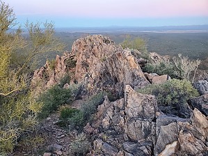
Ragged Top's little sister by Mike_W  Overview OverviewWolcott peak is the lower peak just Southeast of Ragged Top. This hike starts at the same place as Ragged Top and in the last few years, it appears that someone made a nice trail to the saddle between Ragged Top and Wolcott Peak. Some faint trails are going from the Southwest side of the saddle up Wolcott peak, but those trails disappear at a certain point and it's necessary to do some rock climbing to get to the summit. The rock climb is probably similar in difficulty to the climb up Ragged Top, but it's shorter. Desert Bighorn Sheep Policy The Ironwood Forest National Monument requests that persons not enter its Desert Bighorn Sheep Management Area from January 01 through April 30 annually. Unlike the mandatory restriction in the Pusch Ridge Wilderness, this Ironwood Forest recommendation is strongly encouraged in order to protect Desert Bighorn sheep during lambing season.
Dog Policy Dogs are allowed but not recommended due to the large amount of cholla, however, if you stay on the road or trail, the cholla probably wouldn't be a problem. Dogs must be leashed when on public land within the Monument, except when being used for hunting or when being used for livestock operations. Hike If you parked on the main road without making a left at the turn-off OR if you parked at a camping pullout like I did (for non-4x4 vehicles or for hikers who want to do a bit more), simply follow the dirt road South for roughly 1 mile until you see the 4x4 high clearance parking area and a cattle guard type gate that you can walk through. Right before this parking lot, you will see a branch going left, right, and straight. Just take the straight path which will lead to the 4x4 parking area. From here, walk through the cattle guard, and within about 1 minute you will cross a wash. There should be cairns on both sides of the wash. This trail will zig-zag and cross the wash again further up and you should be at the saddle roughly 2/3 of a mile after crossing the cattle guard. Once at the saddle, continue following the trail until you are near the back side of the saddle as if you were going to continue to Ragged Top. Near the backside of the saddle, you should see a branch that turns left and goes in the direction of Wolcott peak. Take this branch and keep in mind that there are a few good ways to go and many bad ways! The higher you get the less likely you will see a trail and at a certain point you will need to do some basic rock climbing. I only saw a few cairns the entire way from the saddle to the peak, but it should be fairly obvious which way to go. From the saddle to the peak is roughly 1/3 of a mile. There should be a registry under a few rocks at the high point. From the high point, you will have excellent views of Ragged Top and Pichacho peak to your North. Reverse your path to get back down again. Gate Policy: If a gate is closed upon arrival, leave it closed after you go through. If it is open, leave it open. Leaving a closed gate open may put cattle in danger. Closing an open gate may cut them off from water. Please be respectful, leave gates as found. The exception is signage on the gate directing you otherwise.
Check out the Official Route and Triplogs. Leave No Trace and +Add a Triplog after your hike to support this local community. | |||||||||||||||||||||||||||||||||||||||||||||||||||||||||||||||||||||||||||||||||||||