Route Editor

| Guide | ♦ | 100 Triplogs | 0 Topics |
details | drive | no permit | forecast | route |
stats |
photos | triplogs | topics | location |
| 1.5k | 100 | 0 |
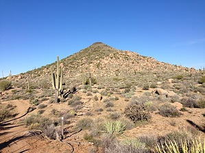
Pleasant desert stroll by Crzy4AZ  This 4.1-mile lasso loop in the northern section of the McDowell Sonoran Preserve is a gentle meander around the circumference of a small cone-shaped mountain. This description starts from the Brown’s Ranch Trailhead which offers bathrooms, water, and a nice educational board with a timeline of human history in the McDowell mountains. Mountain bikers, trail runners, and hikers will enjoy the firmly packed wide trail with minimal elevation change. This 4.1-mile lasso loop in the northern section of the McDowell Sonoran Preserve is a gentle meander around the circumference of a small cone-shaped mountain. This description starts from the Brown’s Ranch Trailhead which offers bathrooms, water, and a nice educational board with a timeline of human history in the McDowell mountains. Mountain bikers, trail runners, and hikers will enjoy the firmly packed wide trail with minimal elevation change.From the trailhead go 0.1 miles and take Upper Ranch Trail 0.7 miles to the intersection with Cone Mountain Trail (at sign marker #UR4). These trails in the McDowell Sonoran Preserve are extremely well-signed, and it would be difficult to get lost in this area. At the intersection between Upper Ranch Trail and Cone Mountain Trail, you can proceed in either direction depending on the time of day and sun exposure or your desire to connect with other trails in the area. I chose clockwise to keep the sun at my back in the early morning. Brittlebush and saguaro are the predominant flora, and there are scattered granite boulder formations to catch your eye. Brown’s Mountain is in view for much of the hike to the northeast with a peak of 3,253 feet. Cone Mountain trail continues for 2 miles with slight elevation change and easy, wide turns. Finally you dead end into Upper Ranch trail and continue back southeast 1.3 miles to the trailhead.
Check out the Official Route and Triplogs. Leave No Trace and +Add a Triplog after your hike to support this local community. | |||||||||||||||||||||||||||||||||||||||||||||||||||||||||||||||||||||||||||||||||||||||||||||||||||||||||||||||||||||||||||||||||||||||||||||||||||||||||||||||||||||||||||||||||||||||||||||||