Route Editor

| Guide | ♦ | 7 Triplogs | 0 Topics |
details | drive | no permit | forecast | route |
stats |
photos | triplogs | topics | location |
| 30 | 7 | 0 |
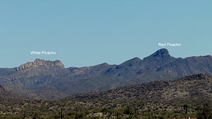
Pink Picacho by Barrett   Red Picacho's distinctive summit can be seen from almost any high point in a thirty-mile radius, luring peak baggers who fall within her spell. Along with White Picacho, both are dramatic landmarks listed as part of the Hieroglyphic Mountains, though they seem more topographically linked to the Buckhorn mountains, which lie just northeast. Red Picacho's distinctive summit can be seen from almost any high point in a thirty-mile radius, luring peak baggers who fall within her spell. Along with White Picacho, both are dramatic landmarks listed as part of the Hieroglyphic Mountains, though they seem more topographically linked to the Buckhorn mountains, which lie just northeast.Geologically, they are comprised of igneous volcanic (Dacite) and extrusive volcanic (Rhyodacite) flows. The geologic survey of the area makes no distinction between the two, so until someone provides a further explanation, I'm going with red/brown rock and grey/white rock.
Fauna is also typical of the area, with Wild Burros often seen (or heard), along with free-range cattle and their patties. The strong smell of what was most likely Mountain Lion urine greeted me at the base of White Picacho on one of my trips as well. The trailhead is located at the end of North Castle Hot Springs Road, where the remains of a mining operation, including several shafts, are all that is left. You can see the Golden Slipper lode gold mine just southeast of the turnoff, and the area is known for an abundance of surface gold, so keep your eyes peeled. After parking, you'll head straight for Red, finding a steep wash with some cool rock formations to get you started. There is a dirt-bike trail that appears to head in the right direction but will veer off to the east. This is the return of your loop if you choose to do Red first and then White. Continue off-trail, staying to the right of the main drainage from Red's saddle, and head right up. The path is moderate, with a few scrambles. Catclaw and other hazards bloodied the shins of the HAZ members who chose to wear shorts on our trip. When you reach the saddle, you have several options.
Once you reach the summit, you will be rewarded with outstanding views in every direction. The summit register includes a surprising range of climbers from age 12 to 72, with a few witty remarks thrown in. After proceeding down, you have the option of returning the way you came or adding White Picacho to your day. Being only a short distance away and much easier than Red, most will want to make a loop of this and proceed north on the left slope of several small peaks on the way to White. A game trail (uncairned) leads most of the way, and at times you can make pretty good time to the base of White. Look for a break roughly in the center of the step/cliffs; as you approach, it should be pretty apparent which way to go. A scramble will get you to a flat area below the summit where you will turn left up a notch and then right up the solid rock to the top. The summit has similar great views of the area, with a little nicer seating and picturesque white stone. Another summit register can be found as well. When you're ready to head back, drop down the way you came to the soft saddle, where you should head due east down the drainage to the dirt-bike trail at 33.96707 N -112.50171 W. Take this south (right) along rolling hills back to the trailhead. There are a few spurs on your left, but you should be fine if you stay right and on the more traveled path. As with all hikes in remote areas, particularly off-trail routes that involve some climbing, make sure you have the necessary experience, hike with competent partners (or make sure someone knows your plans and expected return time), and above all, use your head. Check out the Official Route and Triplogs. Leave No Trace and +Add a Triplog after your hike to support this local community. | |||||||||||||||||||||||||||||||||||||||||||||||||||||||||||||||||||||||||||||||||||||||||||||||||||||||||||||||||||||||||||||||||||||||||||||||||||||||||||||||||||