username
X
password
register
for free!
help
 

Rhyodacite Canyon, AZ

Guide 15 Triplogs  0 Topics
  3.9 of 5  
Fav
Wish
1
details
drive
no permit
forecast
route  
stats
photos
triplogs
topics
location
304 15 0
Statistics
tap row or icons for details
Difficulty 1.5 of 5
Distance One Way 1.6 miles
Trailhead Elevation 1,591 feet
Elevation Gain 498 feet
Accumulated Gain 660 feet
Kokopelli Seeds 3.8
 Interest Off-Trail Hiking & Seasonal Creek
unreported if dogs are allowed
editedit > ops > dogs to adjust
feature photo
Photos Viewed All MineFollowing
Will recalculate on button tap!
29  2024-02-01 jameslcox44
9  2024-01-15 clayncallaway
10  2023-01-29 fdv75
10  2021-03-15 AugustWest
10  2021-03-14
Peak 2290 - Goldfields
DixieFlyer
44  2020-11-21 adilling
13  2019-01-09
Rhyodacite Canyon and Peak 2578
DixieFlyer
25  2017-03-04
Trans Goldfield
hikingaz2
Page 1,  2
Author
author avatar Guides 16,843
Routes 17,472
Photos 24
Trips 1 map ( 6 miles )
Age 28 Male Gender
Location HAZ, TrailDEX
Associated Areas
list map done
Phoenix Region
Historical Weather
Trailhead Forecast
Radar Map
Expand Map
Preferred Feb, Jan, Dec, Mar
Sun  6:02am - 6:48pm
Official Route & 3 Rts
 
4 Alternative


remove free decal offer

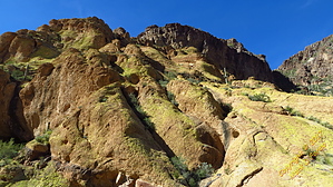
Familiarize yourself with Goldfield Hi Country via Gateway Canyon, AZ.


The turnoff for this trail is approximately 2.75 miles into the Gateway Canyon hike. You will see the canyon open up for you on the right at this point bushwhack your way down into the wash and follow it to your hearts content. You can return the way you came or connect to one of many other routes.


    Check out the Official Route and Triplogs.
    Leave No Trace and +Add a Triplog after your hike to support this local community.

    One-Way Notice
    This hike is listed as One-Way.

    When hiking several trails on a single "hike", log it with a generic name that describes the hike. Then link the trails traveled, check out the example.
    WARNING! Hiking and outdoor related sports can be dangerous. Be responsible and prepare for the trip. Study the area you are entering and plan accordingly. Dress for the current and unexpected weather changes. Take plenty of water. Never go alone. Make an itinerary with your plan(s), route(s), destination(s) and expected return time. Give your itinerary to trusted family and/or friends.

     Permit $$
    None


     Directions
    or
     Road
    Paved - Car Okay

    To hike
    Take Bush highway east from Thomas or Usery to trail head just west of Blue Point Bridge or take Bush highway from Saguaro lake West to just accross the Bridge. Multi car parking in small lot just off the highway
    page created by AZLOT69 on Feb 04 2014 5:47 pm
     90+° 8am - 6pm kills
    helpcorrectionissue

    end of page marker