 Route Editor

| Guide | ♦ | 54 Triplogs | 0 Topics |
details | drive | permit | forecast | 🔥 route |
stats |
photos | triplogs | topics | location |
| 184 | 54 | 0 |
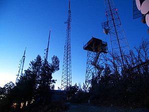
where red lights mean go by PrestonSands  The Bigelow Trail provides an easy hike that connects the Catalina Highway to the towered summit of Mount Bigelow. Mount Bigelow, at 8550 feet, is the second-highest named summit in the Santa Catalina Mountains. On this trail, you will find wonderful views and an easy peak bag. The Bigelow Trail can also be done in combination with the Butterfly Trail, which it connects with. The Bigelow Trail provides an easy hike that connects the Catalina Highway to the towered summit of Mount Bigelow. Mount Bigelow, at 8550 feet, is the second-highest named summit in the Santa Catalina Mountains. On this trail, you will find wonderful views and an easy peak bag. The Bigelow Trail can also be done in combination with the Butterfly Trail, which it connects with.The hike begins at a trailhead parking area directly across the highway from the Organization Ridge Road turnoff. Just west of the trailhead's restroom building, a large trail sign, and map mark the beginning of the Bigelow Trail. The Bigelow Trail begins by climbing northward into the ponderosa pine forest but soon tracks northwest along a mountainside above the Catalina Highway.
The Bigelow Trail reaches a saddle and a four-way trail junction with a little sign at 0.65 miles, where the Kellogg Trail departs to the right, and the Butterfly Trail continues straight ahead. Turn left to continue on the Bigelow Trail. From the saddle, the Bigelow Trail heads west along the ridgeline but soon opts for the rocky southern slope of Mount Bigelow, where it leaves the fire damage behind. The Bigelow Trail comes to an end upon arriving at a service road at 0.9 miles, amid the numerous communication towers of Mount Bigelow's summit. Turn right onto the service road and continue for 0.1 miles to the fire lookout tower to reach the true summit. A few feet to the east of the fire tower, you will find the USGS benchmark set into bedrock, minus the elevation (8550 feet). From the summit, there are spectacular views in almost every direction, both near and far. Many of southern Arizona's sky islands are visible. For a longer return hike, one can descend the service road or turn onto the Kellogg or Butterfly Trails. Otherwise, return the way you came. Check out the Official Route and Triplogs. Leave No Trace and +Add a Triplog after your hike to support this local community. One-Way Notice This hike is listed as One-Way. When hiking several trails on a single "hike", log it with a generic name that describes the hike. Then link the trails traveled, check out the example. | |||||||||||||||||||||||||||||||||||||||||||||||||||||||||||||||||||||||||||||||||||||||||||||||||||||||||||||||||||||||||||||||||||||||||||||||||||||||||||||||||||||||||||||||||||||||||||||||||||||||||


