 Route Editor

| Guide | ♦ | 24 Triplogs | 0 Topics |
details | drive | no permit | forecast | route |
stats |
photos | triplogs | topics | location |
| 36 | 24 | 0 |
The Peaceful East by chumley  Reported 2021-01-17 Reported 2021-01-17Signed private property. Overview This is an unofficial trail, but is very well-traveled and maintained. It climbs to the top of Dixie Peak 2429 in the Phoenix Mountain Preserves, ascending the eastern ridge from the residential PV neighborhood accessed from Tatum and Mockingbird Lane. Description This hike begins at the cul-de-sac of East White Lane in Paradise Valley. On-street parking is permitted during daylight hours only, but at the time of this writing, rarely will you find more than 2-3 cars parked, even on a busy weekend. The trail is not marked but is easily found, ascending uphill directly from the cul-de-sac.
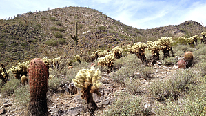
This east ascent provides nice views of Mummy Mountain, Camelback, the McDowells, and Four Peaks, as well as views of some impressive Paradise Valley homes and back yards. There are numerous veins of prominent white quartz rock along the route, providing for some more unique geological experiences than are typically found on other trails in the preserve. Additionally, there are a couple of dense thickets of teddy bear cholla that seem atypical for the preserve as well. While the trail goes through these thickets, the cholla never poses a threat to the hiker passing by. In addition to the cholla, ample ocotillo and barrel cactus will be encountered along the way, as well as creosote and desert wildflowers when in season. This is a nice alternative to other trails in the preserve, especially if you are looking for a quieter, more peaceful experience void of many other hikers. (Note, you are more likely to encounter others on the peak itself, as many ascend the more popular trail from the west.) You may return down the mountain by the same route for a simple 2-mile out-n-back, or you may continue into the preserve for a longer hike by descending the more popular western route. Check out the Official Route and Triplogs. Leave No Trace and +Add a Triplog after your hike to support this local community. One-Way Notice This hike is listed as One-Way. When hiking several trails on a single "hike", log it with a generic name that describes the hike. Then link the trails traveled, check out the example. | |||||||||||||||||||||||||||||||||||||||||||||||||||||||||||||||||||||||||||||||||||||


