Route Editor

| Guide | ♦ | 25 Triplogs | 0 Topics |
details | drive | no permit | forecast | 🔥 route |
stats |
photos | triplogs | topics | location |
| 388 | 25 | 0 |
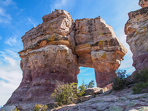
it's all about the destination by eru   Overview OverviewSierra Ancha Wilderness off-trail hike starting off of upper Hwy 288 (The Young Highway) for this out-n-nack hike to Elephant Rock Arch. You might consider including a peek over an unnamed canyon along the nearby edge of the mesa. Hike From the parking area on 288, it's pretty moderate off-trail through rolling fairly open forest, with a few gullies to drop in and out of that don't pose any real difficulty. The worst aspect is the grapefruit to football-sized rocks littering the forest.
The climb up to the arch isn't too bad - an open forest with some cattle tracks going through it. GPS is recommended due to this mostly being under treeline until you're basically at the arch (slope angle shading for the climb to the arch itself is handy), but don't spend too much effort trying to follow the official route here. I was within 300 feet of it most of the time when I checked my position occasionally and didn't hit any hazards. Depending on the time of year you might want to go a little high or low to avoid vegetation, etc. It's a good general path to follow, but there are no needles to be threaded aside from perhaps getting up onto the rocks where the arch is (though options there are pretty obvious). If you're experienced with reading natural features and placing yourself on a map you'd probably be fine, heading back to the highway it's fairly obvious where the open slope with the ruins are, and once past it you can aim via McFadden Peak (non horse-trail) with the lookout on it. I'm unsure of visual reference points heading over, but if you keep a steady elevation line you should eventually get sight of elephant rock. Great views out from the arch itself and the surrounding area, it's well worth wandering around a bit, taking it in, wrapping up around the back of it, etc. Given how scenic it is and the proximity to the highway I'm surprised there's not at least a social or old horse trail here. The terrain isn't rough, but it's also pretty forgettable for the most part. Notes: You can do this as a loop hike vs there and back by combining this with the related McFadden Horse Trail hike as described in this triplog, while there are more direct connectors available the one in this guide is on the more reasonable side. :) Check out the Official Route and Triplogs. Leave No Trace and +Add a Triplog after your hike to support this local community. | ||||||||||||||||||||||||||||||||||||||||||||||||||||||||||||||||||||||||||||||||||||||||||||||||||||||||||||||||||||||||||||||||||||||||||||||||||||||||||||||||||||||||||||||||||||||||||||||||||