 Route Editor

| Guide | ♦ | 1 Triplog | 0 Topics |
details | drive | no permit | forecast | 🔥 route |
stats |
photos | triplog | topics | location |
| 0 | 1 | 0 |
take a ride on the tri-tip turnpike by eru  Overview OverviewThis connects McFadden Horse Trail #146 with Elephant Rock Arch, allowing for a loop hike with either a shuttle at the Elephant Rock Arch area or simply walking down 288 for 45 min or so. Counterclockwise would be my preference - going up vs down #146, wrapping around from the viewpoint at the end of #146 to the arch really puts things into perspective, and from there it's just some moderate xc back to the road. 288 is low traffic and you'll hear people coming, there's always at least a drainage ditch to step into, and people driving tend to be friendly / bewildered / concerned. The otherwise excellent guide to McFadden Horse Trail #146 ends with:
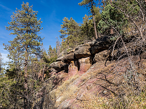
Challenge accepted. :) Intermediate off-trail hiking experience & route-finding experience required by at least one person in the party. Hike Start from the scenic viewpoint at the end of McFadden Horse Trail #146. The GPS Route is a bit short because I cut out the part where we dropped early to check out if there was an obvious drop through the cliff bands along the west side of the ridge near the end of #146 as the incorrect OSM route seems to indicate. It's probably doable, but looked like a bushwhacking cliffout backtracking shitshow so we came back up and decided to check out the gully we ended up using. Backtracking from the scenic viewpoint it's an easy drop to the gully once you go far enough to clear the cliff bands - this will be obvious if you have a map with slope angle shading. We cut in early, but you could go down the gully further to the north and it'd be a gentler entry. The east side has a decent amount of micro cliff outs, the west side can have its own obstacles, the creek bed itself is relatively pleasant. We hopped to either side as terrain dictated until my partner Sara found a cow path on the western side of the gully, maybe 50ft upslope. This drops down from the peninsula between the two gullies earlier than is indicated by GPS because I was having fun boulder hopping the creek itself. :p That'd be an alternate point of entry, but less desirable unless you're skipping #146's viewpoint, but why would you do that? The cattle path is well worn and traverses NW, traverses across an arm separating this from another gully to the west, then continues along the eastern side of it and then drops. At a few points we considered abandoning it and dropping more directly, but you don't lose a ton of elevation just following it and we were a) curious about bovine path finding b) figured it's guaranteed to work and it looked like there were scattered cliff-outs below us. Heck, they even do a nice set of switchbacks around a large boulder at one point. Dropping along the second (western) gully, the cow path split at one point. We stayed high, it petered out, we dropped and met up with the lower branch. So stick skiers left / down if you see a branch at that point. Once down, it's time for a slog. Over a gentle climb of 120 feet traverse through open forest (20-30deg angle) to reach Elephant Rock Arch. This is easier than a lot of forested canyon wall trips I've done, but walking on a slope isn't ideal. No bushbashing until you're right at the arch, no obstacles, but some occasional deadfall to deal with and grapefruit to football-sized rocks well embedded in the hillside. We did this without trekking poles but would have preferred to have brought them. Near the end of this are some really cool multicolored rocks (we stayed below them to be conservative and avoid being cliffed out above them, and also so we could look at them as we passed them heh). These are the only real attraction of this hike. Past these you'll see similar-looking grey cliff bands. We chose to go above these (some easy class 3 scrambling required)... and ended up above the arch. It's a cool spot though! If you decide to wander around there, you can get to the "normal" arch viewing area by backing up until terrain mellows out, then drop SE and come around up the side of the arch as indicated via GPS. Now you're at the end of Elephant Rock Arch. Note I'm sure you can cut this more directly, but this keeps it to a pretty easy class 2 for the most part - with short days we didn't want to spend too much time backtracking. Water Sources There was a truly disgusting small pool near the bottom of the second (western) gully. This would probably be flowing in the spring, but would still have a lot of cattle interaction. Check out the Official Route and Triplog. Leave No Trace and +Add a Triplog after your hike to support this local community. One-Way Notice This hike is listed as One-Way. When hiking several trails on a single "hike", log it with a generic name that describes the hike. Then link the trails traveled, check out the example. | ||||||||||||||||||||||||||||||||||||||||||||||||||||||||||||||||||||||||||||||||||||||||||||||||||||||


