Route Editor

| Guide | ♦ | 13 Triplogs | 0 Topics |
details | drive | permit | forecast | route |
stats |
photos | triplogs | topics | location |
| 228 | 13 | 0 |
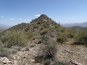
Best view in the Goldfields! by CannondaleKid  Overview OverviewWhile not designated by name or altitude on any official maps, Panorama Peak is well worthy of the name, with a true panorama of awesome views. Warning The usual for any off-trail hikes... be prepared!
I have not been able to find any information about when it was named nor by who. Hike Panorama Peak can be reached from almost any direction, the likeliest routes are from the south or the west. I chose the western approach for several reasons... I'd already been halfway the previous month so had a good route already mapped out, it was the shortest drive into Bulldog from a gated entrance, and best of all, it was the shortest direct route, almost straight east from the designated trailhead on Forest Road #10. From the trailhead you can begin one of two ways: 1. Circle the hill immediately to the east and follow a lower route. 2. Get your heart rate going right away by climbing the hill and following the ridge east. After several hikes, I'll take #2 every time. Once at the top you will find a faint trail sometimes used by range horses providing the most direct route. (The lower route had more brush, more ups & downs in various washes) Once you hit the last wash it is simply a matter of continuing eastward up the largest drainage. Once you reach the bare rock areas of the drainage just continue up. Much of the time you can stay in the drainage, other times you will climb up the side to avoid a steep dry fall or thick and thorny brush. On the ascent my recommendation is to stay to the right side of the drainage whenever you have to leave it... the left side has less vegetation, but the terrain is loose rock which provides more hazards, I know, that's what I did the first time out here. But whatever small detours you make, don't worry, you can't get lost if you just continue up the drainage to the top. Just short of a mile and 1,000' of elevation gain you will reach the saddle. This is a good spot to take a short break while taking in the view not many folks get to see. After your snack/photo break, continue east along the canyon floor as it curves slightly south and back east again. Although you cannot see Panorama Peak from the canyon, as you reach the end what may appear to be the destination is actually a false-summit. Continue all the way up to the saddle just to the left of a nice rock outcrop that turkey vultures like to show-off and spread their wings wide. When you reach this saddle, if you take a look slightly north of east but not up the slope, will catch a glimpse of Panorama Peak. If you don't look in that direction, you'll simply climb toward the 'summit' until you reach it, only to realize Panorama Peak is another tenth of a mile east. It's an easy jaunt across a short saddle, followed by the last ascent to the summit. If you curve around the left side, the final ascent is easier with just a dozen feet of rock-climbing. Once at the top it's time to take a deep breath, drawing in the awesome views in all directions. Unfortunately after two days of gusty winds, the dusty haze in the air didn't help my photos any. But in the end, there is no way photos can do justice to the view. Water Sources While one may encounter the odd pool after recent rains, there are no reliable sources along the way. Gate Policy: If a gate is closed upon arrival, leave it closed after you go through. If it is open, leave it open. Leaving a closed gate open may put cattle in danger. Closing an open gate may cut them off from water. Please be respectful, leave gates as found. The exception is signage on the gate directing you otherwise. Check out the Official Route and Triplogs. Leave No Trace and +Add a Triplog after your hike to support this local community. | |||||||||||||||||||||||||||||||||||||||||||||||||||||||||||||||||||||||||||||||||||||||||||||||||||||||||||||||||||||||||||||||||||||||||||||||||||||||||||||||||||||||||||||||||||||||||||||||