Not recommended with an actual hangover by batman1
Warning
Please note while this is not a difficult trail, some may find it a bit much. It hugs a fine line. Hikers with a fear of footing or balanced-challenged on uneven rock surfaces should be careful.
Overview
Some of the BEST views in Sedona are along the Hangover Trail. However, it does not begin or end at a trailhead. The easiest access is a 7-mile lasso loop utilizing Munds Wagon Trail #78. Full details in Mitten Ridge - Bear Paw Loop. Statistics here are one-way for Hangover Trail propper.
Hike
Accessed via the 0.5-mile Cow Pies Trail over scenic slick rock and marked by white painted spots on the rock. At the end of the Cow Pies Trail is a sign indicating the beginning of the Hangover Trail.
The official Hangover Trail climbs and traverses the sandstone slopes until it reaches a saddle in the ridgeline. Footing along this section (and the entire trail) can be a bit tricky, with the trail frequently sloping to the side towards long drop-offs. Views in all directions are abundant from this saddle.
The trail begins its descent past the saddle and traverses under numerous overhanging sandstone cliffs, giving the trail its name. These are very interesting. Eventually, the trail descends more quickly down steep slickrock slopes. The white paint spots lead the way on all slickrock sections of the trail. Eventually, the trail descends back to the Munds Wagon Trail.
When hiking several trails on a single "hike", log it with a generic name that describes the hike. Then link the trails traveled, check out the example.
WARNING! Hiking and outdoor related sports can be dangerous. Be responsible and prepare for the trip. Study the area you are entering and plan accordingly. Dress for the current and unexpected weather changes. Take plenty of water. Never go alone. Make an itinerary with your plan(s), route(s), destination(s) and expected return time. Give your itinerary to trusted family and/or friends.
Permit $$
Red Rock Pass - may or may not be required. Go to Red Rock Pass then check "When is a Red Rock Pass Required?". If you have questions contact the Coconino forest service.
Directions
Road
High Clearance possible when dry
To hike Drive 1 mile up Schnebly Hill Road from the traffic circle on AZ-79. The Huckaby / Margs Draw Trailhead is on the left. There is a Red Rock Pass Vending unit at the trailhead, and a pass is required for parking.
Alternatively, drive 4 miles up Schnebly Hill Road to the Cow Pied Trailhead. This will shorten the hike. Schnebly Hill Road has really deteriorated over the years. It is a slow drive. This used to be passable by most passenger cars. High Clearance (if not 4WD) is required; the drive is a bumpy, rocky, slow trip full of Pink Jeeps and Off-Road Vehicles.
 Route Editor


 Warning
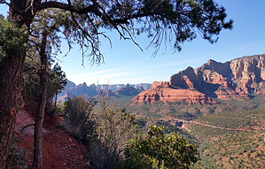


