Route Editor

| Guide | ♦ | 16 Triplogs | 1 Topic |
details | drive | permit | forecast | route |
stats |
photos | triplogs | topic | location |
| 66 | 16 | 1 |
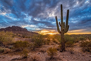
Little Big Park by jman1283  Excellent hike at the San Tan Mountain Regional Park, just outside of Queen Creek, Pinal County. Not far from my home in Chandler. The most strenuous sections are the sandy wash areas that slow you down. Watch for equestrian traffic and cyclists, though I was all alone for most of the hike. Great expansive valley view, towering rock wall cliffs, and amazingly huge ancient saguaro cacti. There are benches throughout the hike where you can rest if you like and take in the vista. Excellent hike at the San Tan Mountain Regional Park, just outside of Queen Creek, Pinal County. Not far from my home in Chandler. The most strenuous sections are the sandy wash areas that slow you down. Watch for equestrian traffic and cyclists, though I was all alone for most of the hike. Great expansive valley view, towering rock wall cliffs, and amazingly huge ancient saguaro cacti. There are benches throughout the hike where you can rest if you like and take in the vista.Check out my gps route. The trail is extremely well marked but if you are like me, it's comforting to have that tracklog just in case you get turned around or confused. Also, because the park is open from 5 AM to 10 PM, if you happen to be hiking before dawn or after dusk you could have the GPS tracklog to guide you when you can't see the signs. The mileage is just over 9 miles. The hike is really along three trails the SanTan Trail, Malpais Trail, and the Hedgehog Trail. I lost the GPS signal briefly along part of the Malpais wash area but you just stay in the wash and follow the signs.
Check out the Official Route and Triplogs. Leave No Trace and +Add a Triplog after your hike to support this local community. | |||||||||||||||||||||||||||||||||||||||||||||||||||||||||||||||||||||||||||||||