Route Editor

| Guide | ♦ | 48 Triplogs | 1 Topic |
details | drive | permit | forecast | route |
stats |
photos | triplogs | topic | location |
| 282 | 48 | 1 |
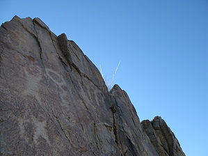
A short but concise survey of the Tucson Mountains by Jeffshadows  Background BackgroundThis little loop is a great way to introduce newbies to all that the Tucson Mountains have to offer. It also serves as a great refresher for all of us who enjoy one from time-to-time. The trail begins in King Canyon, the site of a spectacular wildflower show in the spring after wet winters, visits a petroglyph site, passes by a historic mine ruin, and meanders through classic Sonoran desert all the while. The petroglyphs in the canyon are Hohokam in origin and are believed to date to the period 900-1450 AD. The panels all seem to depict hunting and water-related themes suggesting that the area was once fertile ground for both. The nearby Mam-A-Gah Picnic Area is still used by the Tohono O'odham (Presumed descendants of the Hohokam) for yearly ceremonies and is named for their "Deer Dance." The Gould Mine was enthusiastically promoted as one of the richest copper strikes in Arizona Territory history, a description which fell short of fruition. Digging at the site began around 1905 and ended in 1912, yielding only 1,500 tons of ore. What remains at the site today are the 360 some-odd-foot deep shaft covered by a grate atop a large tailings pile and the remains of an old stone powder storage house. A few old timbers litter the side of the tailings pile and some foundations are scattered here and there, as well. The site is one of the few that visitors from Tucson can drive a passenger car and hike to see preserved mining relics without traveling for hours.
The hike begins at the King Canyon trailhead and follows the King Canyon Trail for about 1 mile to its intersection with the Sendero Esperanza Trail near Mam-A-Gah Picnic Area. The trail departs the parking area and follows a wide track through a vehicle gate as it slowly climbs into the Tucson foothills. An NPS register is encountered at the gate. The track the trail follows into the junction is an old jeep trail, now closed. Its path is littered with small stones and bands of bedrock. The grade is gradual and the goings provide ample opportunity to enjoy views of Wasson ahead and King canyon to the left. As the trail begins to descend into the wash, bear left into the sand and follow the wash for approximately 300 meters until a man-made stone dam backfilled with sediment is encountered in its course. The bands of rock above the wash on both sides here house the majority of the petroglyph panels. Petroglyphs can be found on the pieces of stone that have fallen away from the wall on the north bank of the wash and a few more can be found adorning the rock about 50 meters further down-canyon on the north wall. After visiting the petroglyph site, return to where the King Canyon Trail met the wash. After climbing slightly out of the wash and bearing east, the King Canyon Trail portion of the hike ends when the junction with the Sendero Esperanza Trail is encountered. Take the Sendero Esperanza Trail north further into the foothills. The track becomes a narrower footpath and slightly sandy. The trail achieves a minor saddle and begins to wind its way above an unnamed canyon. Mile Wide mine can be seen to the right as a large pile of gray tailings, and the Gould mine and the old powder house can be seen on the ridge across the canyon, ahead. The Esperanza Trail winds its way over to the Gould mine along a wide track gaining little elevation. Just before arriving at the powder house, the junction with the Gould Mine Trail is encountered. Continue to the mine and powder house for a visit and return to this junction. After leaving the junction, the Gould Mine Trail begins to quickly lose all of the elevation that the King and Esperanza trails gained. It follows a narrow track down into the unnamed canyon passing by spectacular stands of saguaro and a large creosote bosque. After arriving at the wash bottom, the trail follows the wash for a short time and then climbs onto the southern bank and begins to climb slightly through a large forest of teddy bear cholla. The course of the trail follows near Kinney road inside of the Park boundary and then drops back into the stream course of King canyon. Follow the wash back up the canyon for approximately 100 meters and cross over to the switchback built into the canyon wall. The trail ends here near the King Canyon trailhead. Gate Policy: If a gate is closed upon arrival, leave it closed after you go through. If it is open, leave it open. Leaving a closed gate open may put cattle in danger. Closing an open gate may cut them off from water. Please be respectful, leave gates as found. The exception is signage on the gate directing you otherwise.
Check out the Official Route and Triplogs. Leave No Trace and +Add a Triplog after your hike to support this local community. | ||||||||||||||||||||||||||||||||||||||||||||||||||||||||||||||||||||||||||||||||||||||||||||||||||||||||||||||||||||||||||||||||||||||||||||||||||||||||||||||||||||||||||||||||||||||||||||