Route Editor

| Guide | ♦ | 7 Triplogs | 0 Topics |
details | drive | permit | forecast | 🔥 route |
stats |
photos | triplogs | topics | location |
| 50 | 7 | 0 |
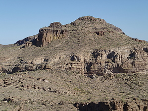
Awesome Skull Cave view! by CannondaleKid   Overview OverviewThis is an off-trail hike with a variety of terrain to deal with from boulder-hopping in the wash to climbing some steep slopes, but nothing like climbing Black Cross Butte right next door. Warning With very little shade if you hike it in hot weather (like I did) you will want to bring plenty of fluids. During monsoon season keep an eye on the weather as flash flooding can be an issue.
In the first and last portion of the hike, you simply follow the wash so you will either be rock/boulder hopping or every once in a while trade it off for some brush including cats-claw. Not real tough, but it can sap your energy more than you realize. At 1.3 miles, turn off to the right and ascend the drainage about 500 feet to a saddle. At the saddle, you will get your first glimpse of the awesome views still to come. From the saddle, follow various game trails in a northwesterly direction, curving slightly left around the first hill, then slightly right around an almost insignificant 'hump' before cutting close along the left side of a steeper rock outcrop into a shallow wash. From there, just shoot for the narrow drainage and ascend 150' to a large mesa, where the views just bumped up another notch. Now just pick your route up the slope to the north. For this final ascent, I'd recommend passing through the left edge of the major cholla field, which seemed to provide a more direct route than attempting a path through the prickly pear. Depending on where you reach the top you might have a small amount of rock scaling but nothing technical. The summit is a reasonably flat triangular mesa about 100 yards southeast to northwest by 75 yards southwest to northeast. Almost in the exact center is a Palo Verde tree, which just happens to be at the summit. Take all the time in the world to slowly walk around the tree, looking off in the distance in every direction. Hmmm, let's see which of the major peaks I can remember off-hand... clockwise from the east, there's Horse Mesa, Black Cross Butte, Tortilla Mountain, Malapais Mountain, Weavers Needle, Geronimo Head, Superstition Ridgeline, Goldfield Mountains, El Recortado, Sheep Mountain, Hells Hip Pocket and finally Four Peaks. Now take a walk around to check out the views of the Salt River below, particularly Sheep Bend then take a glance across and you have probably the closest view of Skull Cave from this side of the Salt River. In short, this hike provided me with many of the best views you can find just a short jaunt up the Apache Trail. Water Sources Probably none for most of the year with some water flow or pools during monsoon season or early spring. Camping I saw a few fire rings at the trailhead so dry camping is an option. Check out the Official Route and Triplogs. Leave No Trace and +Add a Triplog after your hike to support this local community. | ||||||||||||||||||||||||||||||||||||||||||||||||||||||||||||||||||||||||||||||||||||||||||||||||||||||||||||||||||||||||||||||||||||||||||||||||||||||||||||||||||||||||||||||||||||