Route Editor

| Guide | ♦ | 8 Triplogs | 0 Topics |
details | drive | no permit | forecast | route |
stats |
photos | triplogs | topics | location |
| 202 | 8 | 0 |
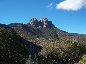
My Little Matterhorn by PhilipMueller   Ahhh, Dos Cabezas. Anyone who has seen these two magnificent peaks from say Hwy 191 or I-10 knows that they are sort of the Matterhorn of Southern Arizona. No, not in the sense of technical difficulty or elevation, but in the sense of unique, eye-catching protrusion from the earth. They shoot up to 8354 ft as masses of solid rock to dominate the skyline of the Dos Cabezas range. And to trump the Matterhorn, there are two of them, right next to each other, and almost exactly the same height! The Spanish translation is "Two Heads," and as we all know, two heads are better than one! Take that, Switzerland! Ahhh, Dos Cabezas. Anyone who has seen these two magnificent peaks from say Hwy 191 or I-10 knows that they are sort of the Matterhorn of Southern Arizona. No, not in the sense of technical difficulty or elevation, but in the sense of unique, eye-catching protrusion from the earth. They shoot up to 8354 ft as masses of solid rock to dominate the skyline of the Dos Cabezas range. And to trump the Matterhorn, there are two of them, right next to each other, and almost exactly the same height! The Spanish translation is "Two Heads," and as we all know, two heads are better than one! Take that, Switzerland!On 03 Jan 2008, my dad and I headed up the rugged, winding Mascot Mine Road for about 5 miles to its driveable end, which dropped us off at about 7218 ft in elevation and less than 1-mile southeast from the peaks. The south peak was just barely visible. We had the choice to head toward the peaks on a faint remnant of a snow-dusted road that would take us to a heavily wooded area just below the southeast side of the peaks. The other option was to follow a fence on a ridgeline to our left, marked with a singular communication tower (Iron Tower Peak), to the south base of the south peak. We chose the snowy road.
Nonetheless, just in case you are wondering, there is also a shovelhead at the base of it. Hey, I'm never one to shy away from an extra clue. From this chute, others have climbed to the top of both of the peaks. I climbed up the chute's first obstacle, which was quite tricky, and was treated to wet rocks, ice, and snow. I started breaking up the ice and snow and chucking it down, but after discussing it with my dad, we decided this wasn't going to be the day to attempt this route, and thus, I climbed back down. Alas, there is another way to get to the top, at least to the top of the south peak. Remember the choice we had to take the ridgeline along the fence to the south peak? Well, that dumps you off at the easiest route up the south peak. At this point, rather than going back down to the road, then back to the truck, then back up the ridge, we scrambled down the entry of the chute and down and around and then back up the east/southeast base of the south peak. This was only about 1/2 a mile, but there was a bit of huffing and puffing. Then we intersected with the end of the ridgeline trail and started heading up the fairly well used/marked route up the south peak. There was a little bushwhacking here and there, but overall, it was pretty straightforward, especially as we got higher. As things cleared out, what looked like a rock staircase appeared, and just beyond it, a steep rockface with a crevice. The stairs were the way up. My dad decided to relax in this area, and I headed up to the top. This route to the top of the south peak is very exposed, and if you slip and fall, you will likely seriously injure yourself or be killed. I took my time. There were occasional cairns that helped. In some cases, I had to double back a few feet to get back on the route. There were a few small bushy areas and one area where I had to climb under a suspended boulder, but overall, it was rock, air, and prayer. It took about 20 minutes from the staircase. The top was drenched with the sun, and the views were fabulous. I could see innumerable mountain ranges for miles. Interestingly, the wind that had been howling at us all day didn't seem to exist up there. Maybe it bowed to my elation. I could have stayed for a long time, but if I did so, my wondering dad would have been calling a rescue chopper to land in the meadow on Iron Tower Peak (assuming the cell phone would work--don't know on that one), so I headed down. Going down required slow and deliberate steps and grips, and I found that I had to think about the way down even though I had just come up. "Did I take that crevice from the right or the left on the way up? I can't see the footholds I used on the way up that I now need on the way down." I made it down alright and we then took the ridgeline down along the fence. From time to time, we had to cross under the fence. It was a relatively easy, approximately 1-mile hike back to the truck. Conclusion Having seen the chute from the bottom and then having seen where one would go from there by peeking over the edge of the south peak, I would recommend that a first-timer who wants to summit one of the Cabezas try the route up the south peak from the ridgeline as the initial interaction. (Supposedly, the south peak is 3 feet higher than the north peak, FYI). After conquering that route, if still interested in the routes up the chute, you could descend the south peak and then scramble down around the east face of the south peak base and head for the chute. After checking out the chute/summiting the peaks (depending on your skill level), you could head down through the forest and come back on the road. You would be doing the reverse route of what my dad and I did. Note, the chute route looked to me like it would require excellent climbing skills. Even the route I took up the south peak was daunting and won't be for everyone. Know your limits, take your time, and be careful! (Also, if you are hungry afterward, there is a superb little Mexican restaurant in Willcox called Salsa Fiesta at 1201 W. Rex Allen Dr., E of I-10, Exit 340; I don't think Switzerland has that, either). Check out the Official Route and Triplogs. Leave No Trace and +Add a Triplog after your hike to support this local community. | ||||||||||||||||||||||||||||||||||||||||||||||||||||||||||||||||||||||||||||||||||